 BGS Data Catalogue
2015
Type of resources
Available actions
Topics
Keywords
Contact for the resource
Provided by
Years
Formats
Representation types
Update frequencies
Service types
Scale
Resolution
-

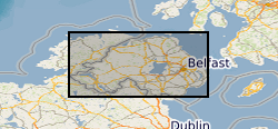
The joint PHE-GSNI-BGS digital Radon Potential Dataset for Northern Ireland provides the current definitive map of radon Affected Areas in Northern Ireland. The Radon Potential map for Northern Ireland shows the estimated percentage of homes in an area exceeding the radon Action Level. This is the basic information to assigning the level of protection required for new buildings and extensions, as described in the Building Research Establishment guidance BR-413 Radon: Guidance on protective measures for new dwellings in Northern Ireland (2004). The Radon Potential map for Northern Ireland is based on PHE indoor radon measurements and 1:10 000 or 1: 250 000 scale digital geology information provided by the Geological Survey of Northern Ireland (GSNI). The indoor radon data is used with the agreement of the Northern Ireland Environment Agency and PHE. Confidentiality of measurement locations is maintained through data management practices. Access to the data is restricted. Radon is a natural radioactive gas, which enters buildings from the ground. Exposure to high concentrations increases the risk of lung cancer. Public Health England (PHE) recommends that radon levels should be reduced in homes where the annual average exceed 200 becquerels per cubic metre (200 Bq m-3), the Action Level. PHE defines radon Affected Areas as those with 1% chance or more of a house having a radon concentration at or above the Action Level. Further information on radon can be obtained from www.ukradon.org
-
The joint PHE-GSNI-BGS digital Indicative Atlas of Radon in Northern Ireland presents an overview of the results of detailed mapping of radon potential, defined as the estimated percentage of homes in an area above the radon Action Level. The Indicative Atlas of Radon in Northern Ireland presents a simplified version of the Radon Potential Dataset for Northern Ireland, with each 1-km grid square being classed according to the highest radon potential found within it, so is indicative rather than definitive. The Radon Potential Dataset for Northern Ireland provides the current definitive map of radon Affected Areas in Northern Ireland. The Indicative Atlas of Radon in Northern Ireland is published in Z Daraktchieva, J D Appleton, D M Rees, K A M Adlam, A H Myers, S A Hodgson, N P McColl, G R Wasson and L J Peake, 2015. Indicative Atlas of Radon in Northern Ireland. PHE-CRCE-017, 22 pp. Radon is a natural radioactive gas, which enters buildings from the ground. Exposure to high concentrations increases the risk of lung cancer. Public Health England (PHE) recommends that radon levels should be reduced in homes where the annual average exceed 200 becquerels per cubic metre (200 Bq m-3), the radon Action Level. Public Health England defines radon Affected Areas as those with 1% chance or more of a house having a radon concentration exceeding the Action Level.
-
The dataset is a subset of the BGS borehole material database, created on August 1st 2015 covering only the Bowland-Hodder geological unit (as defined and mapped by Andrews et al., 2013). It shows all boreholes (name, location and registration details) for which BGS hold borehole material (drillcore, cuttings, samples and their depth ranges). This data will add value to existing NERC (Natural Environment Research Council) data by allowing a simple route for users to identify borehole material from the Bowland-Hodder interval.
-
Scanned images of well logs for oil and gas exploration and appraisal wells drilled on the UK Continental Shelf and held on behalf of the Oil & Gas Authority (formerly the Department of Energy and Climate Change).
-
Scanned collection of seismological journals and offprints. The original collection was compiled by John Wartnaby. John Wartnaby was a curator at the Science Museum, London, and wrote a historical survey of seismology and scientific instruments. His accumulated papers consist chiefly of offprints and articles, and many older British Association seismological reports. The collection is part of the National Seismological Archive.
-

Offprints of articles relating to Geomagnetism from 1822 to 1981. Offprints collected by Kew Observatory, Meteorological Office, Edinburgh and Greenwich Observatory (Herstmonceux castle). The first page of each offprint has been digitised to produce a finding aid.
-

**This dataset has been superseded** The newGeoSure Insurance Product (newGIP) provides the potential insurance risk due to natural ground movement. It incorporates the combined effects of the 6 GeoSure hazards on (low-rise) buildings. This data is available as vector data, 25m gridded data or alternatively linked to a postcode database – the Derived Postcode Database. A series of GIS (Geographical Information System) maps show the most significant hazard areas. The ground movement, or subsidence, hazards included are landslides, shrink-swell clays, soluble rocks, running sands, compressible ground and collapsible deposits. The newGeoSure Insurance Product uses the individual GeoSure data layers and evaluates them using a series of processes including statistical analyses and expert elicitation techniques to create a derived product that can be used for insurance purposes such as identifying and estimating risk and susceptibility. The Derived Postcode Database (DPD) contains generalised information at a postcode level. The DPD is designed to provide a ‘summary’ value representing the combined effects of the GeoSure dataset across a postcode sector area. It is available as a GIS point dataset or a text (.txt) file format. The DPD contains a normalised hazard rating for each of the 6 GeoSure themes hazards (i.e. each GeoSure theme has been balanced against each other) and a combined unified hazard rating for each postcode in Great Britain. The combined hazard rating for each postcode is available as a standalone product. The Derived Postcode Database is available in a point data format or text file format. It is available in a range of GIS formats including ArcGIS (*.shp), ArcInfo Coverages and MapInfo (*.tab). More specialised formats may be available but may incur additional processing costs. The newGeoSure Insurance Product dataset has been created as vector data but is also available as a raster grid. This data is available in a range of GIS formats, including ArcGIS (*.shp), ArcInfo coverage’s and MapInfo (*.tab). More specialised formats may be available but may incur additional processing costs. Data for the newGIP is provided for national coverage across Great Britain. The newGeoSure Insurance Product dataset is produced for use at 1:50 000 scale providing 50 m ground resolution. This dataset has been specifically developed for the insurance of low-rise buildings. The GeoSure datasets have been developed to identify the potential hazard for low-rise buildings and those with shallow foundations of less than 2 m deep. The identification of ground instability and other geological hazards can assist regional planners; rapidly identifying areas with potential problems and aid local government offices in making development plans by helping to define land suited to different uses. Other users of these data may include developers, homeowners, solicitors, loss adjusters, the insurance industry, architects and surveyors. Version 7 released June 2015.
-
The HiRES-1 project acquired airborne geophysical data during 1998. Coverage included the Central Midlands of England and into the associated Welsh Borderland. Survey flying for the collaborative BGS and World Geoscience Corporation Ltd (WGC) high resolution geophysical and environmental survey was completed in early September 1998. The data comprise multi-channel gamma ray spectrometer, magnetometer and dual frequency VLF-EM. Flight line spacing was 400 m with tie lines at 1200 m and the total area surveyed is some 14 000 km2. Flight-line orientations are W–E over the western survey area, SW–NE over the eastern area. Ground clearance was maintained at 90 m in rural areas, increasing to about 240 m in built-up zones. The project and data descriptions are provided in an internal BGS report: R J Peart, R J Cuss, D Beamish and D G Jones, 2003. The High Resolution Airborne Resource and Environmental Survey- Phase 1 (HiRES-1): background, data processing and dissemination and future prospects. British Geological Survey Internal Report, IR/03/112. 28pp.
-
**This dataset has been superseded** The newGeoSure Insurance Product (newGIP) provides the potential insurance risk due to natural ground movement. It incorporates the combined effects of the 6 GeoSure hazards on (low-rise) buildings: landslides, shrink-swell clays, soluble rocks, running sands, compressible ground and collapsible deposits. The newGIP evaluates these hazards using a series of processes including statistical analyses and expert elicitation techniques to create a derived product that can be used for insurance purposes such as identifying and estimating risk and susceptibility. The newGIP is made up of 3 components. 1. Derived Postcode Database (DPD): this dataset contains generalised information at a postcode level and it’s updated on a 6 monthly basis. The DPD is designed to provide a ‘summary’ value representing the combined effects of the GeoSure dataset across a postcode sector area. This product uses Code-Point® Open data to relate postcodes to Ordnance Survey grid references. This dataset is available in a range of GIS formats including Access (*.dbf), ArcGIS (*.shp) or MapInfo (*.tab). 2. Unified Hazards (Vector Dataset): This is a detailed vector dataset providing spatial GIS information that can be used for more specific analysis at a higher resolution (e.g. site/address specific at 1:50k resolution). This dataset also has additional attributes outlining the type and scale of the potential hazards at any one location. This dataset is updated with the release of each version of DiGMapGB-50 and is available in a range of GIS formats including ArcGIS (*.shp) or MapInfo (*.tab). 3. Unified Hazards (Gridded Dataset): This dataset consists of a raster grid derived from the vector dataset; however, due to the raster grid format, the grid only carries limited attribution. Data for the newGIP is provided for national coverage across Great Britain. The newGeoSure Insurance Product dataset is produced for use at 1:50 000 scale providing 50 m ground resolution.
-

Reflectance transformation image of a cast (BGS fossil reference number GSM106161) of the holotype of Charniodiscus concentricus. The original fossil is the property of the Geology Department, University of Leicester, and the fossil is on display at New Walk Museum, Leicester