 BGS Data Catalogue
2016
Type of resources
Topics
Keywords
Contact for the resource
Provided by
Years
Formats
Representation types
Update frequencies
Scale
-
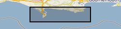
This is a 1:10,000 scale Bedrock geological map for some 800 km2 of the seabed across Weymouth Bay in Dorset. It joins seamlessly to the onshore BGS 1:10,000 scale Digital Geological Mapping (DiGMapGB-10) and therefore shows the coastal geology in detail. It comprises bedrock polygons, faults and limestone bed lines. The map was produced in 2015-16 by digitising against a seamless on- to offshore-shore elevation surface generated from high (1 m bin) resolution bathymetry and coastal Lidar data, collected as part of the Dorset Integrated Seabed Survey (DORIS) project and the Regional Coastal Monitoring Programme of England, made available by the Channel Coastal Observatory under the Open Government Licence. The map can be veiwed using the map viewer at www.bgs.ac.uk/research/marine/doris.html. This map has been produced under the auspices of the Marine Environmental Mapping Programme (MAREMAP), in collaboration between the BGS and the University of Southampton. The map itself should be referred to as: Westhead, R K, Sanderson, D J, Dix, J K. 2016. Bedrock map for the offshore Weymouth Bay area, with seamless coastal joint to BGS onshore (DiGMapGB-10) mapping. Bedrock Geology. 1:10 000 (Marine Environmental Mapping Programme, MAREMAP)
-
Data identifying landscape areas (shown as polygons) attributed with geological names. The scale of the data is 1:50 000 scale. Onshore coverage is provided for all of England, Wales, Scotland and the Isle of Man. Data are supplied as five themes: bedrock, superficial deposits, mass movement, artificial ground and linear features. Bedrock geology describes the main mass of solid rocks forming the earth's crust. Bedrock is present everywhere, whether exposed at surface in outcrops or concealed beneath superficial deposits or water bodies. Geological names are based on the lithostratigraphic or lithodemic hierarchy. The lithostratigraphic scheme arranges rock bodies into units based on rock-type and geological time of formation. Where rock-types do not fit into the lithostratigraphic scheme, for example intrusive, deformed rocks subjected to heat and pressure resulting in new or changed rock types; then their classification is based on their rock-type or lithological composition. This assesses visible features such as texture, structure, mineralogy. Superficial deposits are younger geological deposits formed during the most recent geological time; the Quaternary. These deposits rest on older rocks or deposits referred to as bedrock. The superficial deposits theme defines landscape areas (shown as polygons) attributed with a geological name and their deposit-type or lithological composition. Mass movement describes areas where deposits have moved down slope under gravity to form landslips. These landslips can affect bedrock, superficial or artificial ground. Mass movement deposits are described in the BGS Rock Classification Scheme Volume 4. However this data also includes foundered strata, where ground has collapsed due to subsidence (this is not described in the Rock Classification Scheme). Caution should be exercised with this data; historically BGS has not always recorded mass movement events and due to the dynamic nature of occurrence significant changes may have occurred since the data was released. Artificial (man-made) theme (shown as polygons) indicates areas where the ground surface has been significantly modified by human activity. Whilst artificial ground may not be considered as part of the 'real geology' of bedrock and superficial deposits it does affect them. Artificial ground impacts on the near surface ground conditions which are important to human activities and economic development. Due to the constantly changing nature of land use and re-use/redevelopment, caution must be exercised when using this data as it represents a snapshot in time rather than an evolving picture hence the data may become dated very rapidly. Linear features (shown as polylines) represent geological structural features e.g. faults, folds or landforms e.g. buried channels, glacial drainage channels at the ground or bedrock surface (beneath superficial deposits). Linear features are associated most closely with the bedrock theme either as an intrinsic part of it for example marine bands or affecting it in the case of faults. Landform elements are associated with both bedrock and superficial deposits. All five data themes are available in vector format (containing the geometry of each feature linked to a database record describing their attributes) as ESRI shapefiles and are available under BGS data licence.
-

**This dataset has been superseded** The newGeoSure Insurance Product (newGIP) provides the potential insurance risk due to natural ground movement. It incorporates the combined effects of the 6 GeoSure hazards on (low-rise) buildings. This data is available as vector data, 25m gridded data or alternatively linked to a postcode database - the Derived Postcode Database. A series of GIS (Geographical Information System) maps show the most significant hazard areas. The ground movement, or subsidence, hazards included are landslides, shrink-swell clays, soluble rocks, running sands, compressible ground and collapsible deposits. The newGeoSure Insurance Product uses the individual GeoSure data layers and evaluates them using a series of processes including statistical analyses and expert elicitation techniques to create a derived product that can be used for insurance purposes such as identifying and estimating risk and susceptibility. The Derived Postcode Database (DPD) contains generalised information at a postcode level. The DPD is designed to provide a 'summary' value representing the combined effects of the GeoSure dataset across a postcode sector area. It is available as a GIS point dataset or a text (.txt) file format. The DPD contains a normalised hazard rating for each of the 6 GeoSure themes hazards (i.e. each GeoSure theme has been balanced against each other) and a combined unified hazard rating for each postcode in Great Britain. The combined hazard rating for each postcode is available as a standalone product. The Derived Postcode Database is available in a point data format or text file format. It is available in a range of GIS formats including ArcGIS (*.shp), ArcInfo Coverages and MapInfo (*.tab). More specialised formats may be available but may incur additional processing costs. The newGeoSure Insurance Product dataset has been created as vector data but is also available as a raster grid. This data is available in a range of GIS formats, including ArcGIS (*.shp), ArcInfo coverage's and MapInfo (*.tab). More specialised formats may be available but may incur additional processing costs. Data for the newGIP is provided for national coverage across Great Britain. The newGeoSure Insurance Product dataset is produced for use at 1:50 000 scale providing 50m ground resolution. This dataset has been specifically developed for the insurance of low-rise buildings. The GeoSure datasets have been developed to identify the potential hazard for low-rise buildings and those with shallow foundations of less than 2 m deep. The identification of ground instability and other geological hazards can assist regional planners; rapidly identifying areas with potential problems and aid local government offices in making development plans by helping to define land suited to different uses. Other users of these data may include developers, homeowners, solicitors, loss adjusters, the insurance industry, architects and surveyors.
-

This dataset is the Derived Postcode Database issued as part of the GeoSure Insurance V7 incorporating postcode data from OS Code-Point Open version 2016.1. The GeoSure Insurance Product (including the Derived Postcode Database) represents the end of an interpretation process, starting with the BGS Digital Geological Map of Great Britain at the 1:50,000 scale (DiGMapGB-50). This digital map is the definitive record of the types of rocks underlying Great Britain (excluding the Isle of Man), as represented by various layers, starting with Bedrock and moving up to overlying Superficial layers. In 2003, the BGS also published a series of GIS digital maps identifying areas of potential natural ground movement hazard in Great Britain, called GeoSure. There are six separate hazards considered - shrink-swell clays, slope instability, dissolution of soluble ground, running sand, compressible and collapsible deposits. These maps were derived by combining the rock-type information from DiGMapGB-50 with a series of other influencing factors which may cause the geological hazards (e.g. steep slopes, groundwater). In 2005, the BGS used the GeoSure maps to make an interpretation of subsidence insurance risk for Great Britain property insurance industry, released as the new GeoSure Insurance Product. This represents the combined effects of the 6 GeoSure hazards on (low-rise) buildings in a postcode database - the Derived Postcode Database, which can be accompanied by GIS maps showing the most significant hazard areas. The combined hazard is represented numerically in the Derived Postcode Database as the Total Hazard Score, with a breakdown into the component hazards. The GeoSure Derived Postcode Database (DPD) is a stand-alone database, which can be provided separately to the full GeoSure Insurance Product V7. The methodology behind the DPD involves balancing the 6 GeoSure natural ground stability hazards against each other. The GeoSure maps themselves have a fivefold coding (A to E), and the balancing exercise involves comparing each level across the six hazards e.g. comparing a level C shrink-swell clay area with a level C running sand area. The comparison is done by a process involving expert analysis and statistical interpretations to estimate the potential damage to a property (specifically low-rise buildings only). Each level of each of the hazards is given a 'hazard score' which can then be added together to derive a Total Hazard Score at a particular location (e.g. within a given postcode).
-

Data identifying landscape areas (shown as polygons) attributed with geological names and rock type descriptions. The scale of the data is 1:50 000 scale providing bedrock geology. Onshore coverage is provided for all of England, Wales, Scotland and the Isle of Man. Bedrock geology describes the main mass of solid rocks forming the earth's crust. Bedrock is present everywhere, whether exposed at surface in outcrops or concealed beneath superficial deposits or water bodies. The bedrock geology of Great Britain is very diverse and includes three broad classes based on their mode of origin: igneous, metamorphic and sedimentary. The data includes attribution to identify each rock type (in varying levels of detail) as described in the BGS Rock Classification Scheme (volumes 1-3 ). The bedrock has formed over long periods of geological time, from the Archean eon some 7500 million years ago, to the relatively young Pliocene, 58 million years ago. The age of the rocks is identified in the data through their BGS lexicon name (published for each deposit at the time of the original survey or subsequent digital data creation). For stratified rocks i.e. arranged in sequence, this will usually be of a lithostratigraphic type. Other rock types for example intrusive igneous bodies will be of a lithodemic type. More information on the formal naming of UK rocks is available in the BGS Lexicon of Named Rock Units. Geological names are based on the lithostratigraphic or lithodemic hierarchy. The lithostratigraphic scheme arranges rock bodies into units based on rock-type and geological time of formation. Where rock-types do not fit into the lithostratigraphic scheme, for example intrusive, deformed rocks subjected to heat and pressure resulting in new or changed rock types; then their classification is based on their rock-type or lithological composition, using visible features such as texture, structure, mineralogy. The data are available in vector format (containing the geometry of each feature linked to a database record describing their attributes) as ESRI shapefiles and are available under BGS data licence.
-
Linear features (shown as polylines) represent six classes of geological structural features e.g. faults, folds or landforms e.g. buried channels, glacial drainage channels at the ground or bedrock surface (beneath superficial deposits). Linear features are associated most closely with the bedrock theme either as an intrinsic part of it for example marine bands or affecting it in the case of faults. However landform elements are associated with both bedrock and superficial deposits. The linear features are organised into seven main categories: Alteration area indicating zones of change to the pre-existing rocks due to the application of heat and pressure that can occur round structural features such as faults and dykes. Fault where a body of bedrock has been fractured and displaced by a large scale process affecting the earth's crust. Fold where strata are bent or deformed resulting from changes or movement of the earth's surface creating heat and pressure to reshape and transform the original horizontal strata. Folds appear on all scales, in all rock types and from a variety of causes. Fossil horizons where prolific fossil assemblages occur and can be used to help establish the order in which deposits were laid down (stratigraphy). These horizons allow correlation where sediments of the same age look completely different due to variations in depositional environment. Mineral vein where concentrations of crystallised mineral occur within a rock, they are closely associated with faulting, but may occur independently. Landforms define the landscape by its surface form; these include glacial features such as drumlins, eskers and ice margins. Rock identifies key (marker) beds, recognised as showing distinct physical characteristics or fossil content. Examples include coal seams, gypsum beds and marine bands. The data are available in vector format (containing the geometry of each feature linked to a database record describing their attributes) as ESRI shapefiles and are available under BGS data licence.
-
Data identifies landscape areas (shown as polygons) attributed with type of artificial or man-made ground. It indicates areas where the ground surface has been significantly modified by human activity. Types of artificial ground include: Disturbed ground areas of ill-defined shallow or near surface mineral workings where distinction cannot be made between made and worked ground. Infilled ground areas where original geology has been removed and then wholly or partially back filled includes waste or landfill sites. Landscaped ground areas where surface has been reshaped includes former sand and gravel workings for recreation and amenity use. Made ground man made features including embankments and spoil heaps. Worked ground areas where ground has been removed including quarries and road cuttings. Disturbed ground areas of ill-defined shallow or near surface mineral workings where distinction cannot be made between made and worked ground. Whilst artificial ground may not be considered as part of the 'real geology' of bedrock and superficial deposits it does affect them. Artificial ground impacts on the near surface ground conditions which are important to human activities and economic development. Due to the constantly changing nature of land use and re-use/redevelopment, caution must be exercised when using this data as it represents a snapshot in time rather than an evolving picture hence the data may become dated very rapidly. The data are available in vector format (containing the geometry of each feature linked to a database record describing their attributes) as ESRI shapefiles and are available under BGS data licence.
-
The UK contains extensive resources of coal, both at surface and in the subsurface. It is estimated that onshore these surface and subsurface deposits cover an area of approximately 40,000 km2. This dataset is derived from a 2004 study to assess the potential of the UK onshore coal resources for both exploitation by conventional (mining) and new technologies. Digital data was created using a Geographic Information System (GIS) to produce the delivered output of the original project, a series of paper maps that would identify prospective areas. The dataset layers include: Mining Technologies: Area with technical potential for opencast workings (source Coal Resource Map of Great Britain BGS/Coal Authority 1999) Underground mining exploration prospects Good prospects for abandoned mine methane (AMM) (Mine workings not recovered) Resource area for coal mine methane (CMM) (source Coal Authority Underground Licences, May 2002) Extent of underground workings with 500m buffer zone (based on Coal Authority data, May 2002) New Technologies: Area greater than 1200m from surface with potential for CO2 sequestration Area with good coalbed methane (CBM) potential Underground coal gasification (UCG) potential Coalbed methane (CBM) resource area Coal-bearing strata
-
Data identifying landscape areas (shown as polygons) attributed with type of mass movement e.g. landslip. The scale of the data is 1:50 000 scale. Onshore coverage is provided for all of England, Wales, Scotland and the Isle of Man. Mass movement describes areas where deposits have moved down slope under gravity to form landslips. These landslips can affect bedrock, superficial or artificial ground. Mass movement deposits are described in the BGS Rock Classification Scheme Volume 4. However the data also includes foundered strata, where ground has collapsed due to subsidence (this is not described in the Rock Classification Scheme). Caution should be exercised with this data; historically BGS has not always recorded mass movement events and due to the dynamic nature of occurrence significant changes may have occurred since the data was released. The data are available in vector format (containing the geometry of each feature linked to a database record describing their attributes) as ESRI shapefiles and are available under BGS data licence.
-
**This dataset has been superseded** The newGeoSure Insurance Product (newGIP) provides the potential insurance risk due to natural ground movement at a postcode level. It incorporates the combined effects of the 6 GeoSure hazards on (low-rise) buildings: landslides, shrink-swell clays, soluble rocks, running sands, compressible ground, and collapsible deposits. The newGeoSure Insurance Product evaluates these hazards using a series of processes including statistical analyses and expert elicitation techniques to create a derived product that can be used for insurance purposes such as identifying and estimating risk and susceptibility. The newGeoSure Insurance Product is updated biannually with new releases of Ordnance Survey Code-Point® data (current version used: 2016.3) and is provided for national coverage across Great Britain (not including the Isle of Man). This product is available in a range of GIS formats including Access (*.dbf), ArcGIS (*.shp), or MapInfo (*.tab). The newGeoSure Insurance Product is produced for use at 1:50 000 scale, providing 50 m ground resolution.