 BGS Data Catalogue
Type of resources
Topics
Keywords
Contact for the resource
Provided by
Years
Formats
Representation types
Update frequencies
-

The final borehole information pack from the TH0424 Ground Investigation Borehole drilled as part of the UK Geoenergy Observatories (UKGEOS) Cheshire facility. TH0424 was drilled to TD of 101 m between the 08-Nov-2021 and 30 Nov-2021. Drill core was collected from 2 m – 101 m with 100 mm diameter. This final data release pack from BGS contains composite and digital wireline logs alongside daily driller's borehole records, sedimentary and discontinuity logging and core analysis data. This information pack also contains the Initial and additional Core Scanning datasets from the BGS Core Scanning Facility (https://doi.org/10.5285/b06d44e6-324d-4e19-bf78-a4520b9b87c8 and https://doi.org/10.5285/381e9664-0f43-4e4c-90ae-1b16ba83681b).
-

The borehole information pack from borehole GGC01, site 10 of the UK Geoenergy Observatories (UKGEOS) Glasgow facility. This initial data release pack from BGS contains composite and digital wireline logs; drillers summary logs and prognosis; sample recovery information spreadsheets; and daily driller's borehole records. The cored, seismic monitoring borehole was drilled between 19 November and 12 December 2018 to 199m producing a core of 102 mm diameter. The borehole was wireline logged in December 2018 and a string of 5 seismometers were installed in February 2019. A range of fluid, water and core samples were taken during the drilling process.
-

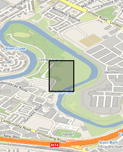
This summary borehole information release is for ‘as-built’ mine water and environmental baseline monitoring boreholes of the UK Geoenergy Observatories (UKGEOS) Glasgow facility at Cuningar Loop. The information pack from BGS contains a brief report with summary tables of locations, drilled depths, screened intervals and illustrative interpretations, and is accompanied with a spreadsheet and shapefile of the borehole locations and drilled depths. The purpose is to give potential users of the Glasgow Observatory an outline of the as-built infrastructure including condition of the target mine workings, as a summary of the more detailed information packs for each borehole. This dataset was updated in June 2020. Further details can be found in the accompanying report http://nora.nerc.ac.uk/id/eprint/526889
-

The borehole information pack from borehole GGA01, site 01 of the UK Geoenergy Observatories (UKGEOS) Glasgow facility. This release from the British Geological Survey (BGS) contains BGS and Drillers’ logs, cased hole wireline data, a listing of archived rock chips and a descriptive report. The mine water characterisation and monitoring borehole was drilled between 11th June and 21st August 2019 (start of drilling to casing installation date) to 52 m drilled depth. The cased borehole was wireline logged and hydrogeologically tested in January 2020. Rock chip samples were taken during the drilling process and have been archived at the National Geological Repository at BGS Keyworth. Further details can be found in the accompanying report http://nora.nerc.ac.uk/id/eprint/528075, DOI https://dx.doi.org/10.5285/0d496c68-f79b-4956-8cd2-4970d1e86145.
-
The data release includes initial interpretation from test pumping of boreholes at the UK Geoenergy Observatories (UKGEOS) Glasgow facility. This release from the British Geological Survey (BGS) covers a programme of test pumping carried out in ten boreholes in January and February 2020. It contains contractors reports and data sheets, BGS data sheets of data logger and manual dip data in the pumped borehole and in the observation boreholes. Step tests and five hour constant rate tests were performed in nine of the boreholes and a slug (falling/rising/head) test was performed in one borehole. Further details can be found in the accompanying report http://nora.nerc.ac.uk/id/eprint/530507
-

The borehole information pack from borehole GGA09r, site 03 of the UK Geoenergy Observatories (UKGEOS) Glasgow facility. This release from the British Geological Survey (BGS) contains BGS and Drillers’ logs, a listing of archived rock chips and a descriptive report. The environmental baseline characterisation and monitoring borehole was drilled between 26th June and 6th August 2019 (start of drilling to casing installation date) to 16 m drilled depth. The cased borehole was hydrogeologically tested in Febuary 2020. Rock chip samples were taken during the drilling process and have been archived at the National Geological Repository at BGS Keyworth. Further details can be found in the accompanying report http://nora.nerc.ac.uk/id/eprint/528082 DOI https://dx.doi.org/10.5285/baf7cc61-4a46-423f-a491-23d107b25001
-

The borehole information pack from borehole GGB05, site 05 of the UK Geoenergy Observatories (UKGEOS) Glasgow facility. This release from the British Geological Survey (BGS) contains BGS and Drillers’ logs, a listing of archived rock chips and a descriptive report. The environmental baseline characterisation and monitoring borehole was drilled between 5th July and 11th October 2019 (start of drilling to casing installation date) to 46 m drilled depth. The cased borehole was hydrogeologically tested in Febuary 2020. Rock chip samples were taken during the drilling process and have been archived at the National Geological Repository at BGS Keyworth. Further details can be found in the accompanying report http://nora.nerc.ac.uk/id/eprint/528084 DOI: https://dx.doi.org/10.5285/e0ec7462-b731-47c6-93d6-e4613fb44be0
-

The borehole information pack from borehole GGB04, site 05 of the UK Geoenergy Observatories (UKGEOS) Glasgow facility. This release from the British Geological Survey (BGS) contains BGS and Drillers’ logs, a listing of archived rock chips and a descriptive report. The environmental baseline characterisation and monitoring borehole was drilled between 4th July and 1st August 2019 (start of drilling to casing installation date) to 16 m drilled depth. The cased borehole was hydrogeologically tested in Febuary 2020. Rock chip samples were taken during the drilling process and have been archived at the National Geological Repository at BGS Keyworth. Further details can be found in the accompanying report http://nora.nerc.ac.uk/id/eprint/528083 DOI https://dx.doi.org/10.5285/d31f33b8-b34a-4843-b2d2-545722bf94ae
-
The UK Geoenergy Observatories (UKGEOS) Glasgow 3D coal mine model outputs, created by the British Geological Survey, provide a semi-regional overview of the depth and extent of surveyed and probable coal mine workings, plus stone and coal roads surveyed within the mines. The model allows users to visualise the surveyed and probable coal mine workings to be found beneath this part of Glasgow, applicable at a scale of around 1: 25,000 to 1: 10,000. The data is supplied as grids, triangulated surfaces over a 5 by 4.15 km area, with the depth range to around 300 m below Ordnance Datum. The mine extents are ‘cut out’ of the UKGEOS Glasgow post-drill bedrock model. This model describes both surveyed (recorded on mine abandonment plan) and probable coal mine workings. An area of probable workings has been updated to account for the results of drilling borehole GGC01. Further details and model limitations can be found in the accompanying metadata report http://nora.nerc.ac.uk/id/eprint/531157/
-

The UK Geoenergy Observatories (UKGEOS) Glasgow bedrock model outputs, created by the British Geological Survey, provide a semi-regional overview of the depth and extent of bedrock lithostratigraphic units, coals and faults. The model allows users to visualise the likely subsurface sequence to be found beneath this part of Glasgow, applicable at a scale of around 1: 25,000 to 1: 10,000. The data is supplied as grids, triangulated surfaces and shapefiles over a 5 by 4.15 km area, with the depth range to around 350 m below Ordnance Datum. This model describes an interpretation of the bedrock geology after the UKGEOS Glasgow boreholes had been drilled, the results of the nine UKGEOS boreholes that penetrated bedrock have been incorporated. Further details and model limitations can be found in the accompanying metadata report http://nora.nerc.ac.uk/id/eprint/531157/