 BGS Data Catalogue
Wind
Type of resources
Topics
Keywords
Contact for the resource
Provided by
Years
Formats
Representation types
Update frequencies
-

Wind, sediment transport and surface morphological data collected at Sand Creek during a month long field campaign in March and April 2019 to investigate protodune development under bimodal winds. Data is used in the accepted paper ‘Dune initiation in a bimodal wind regime’, Journal of Geophysical Research: Earth Surface, by Delorme, P., Wiggs, G.F.S., Baddock, M.C., Claudin, P., Nield, J.M. and Valdez, A. (accepted 18th September 2020, article reference number 2020JF005757R; https://repository.lboro.ac.uk/articles/Dune_initiation_in_a_bimodal_wind_regime/12973817) Surface morphological data: This is terrestrial laser scanned (TLS) data collected of the creek sand surface during multiple visits. The data is raw point cloud format in text columns of x, y and z coordinate data. It has been orientation in local format (the origin is located at 13UTM 443152, 4184478). *_full_lowres cover the whole creek surface and the banks on either side. * is the date that the data was collected in yymmdd format. All other data is high resolution section of the actual creek surface within the channel. Each data set uses the same coordinate system. Data can be viewed in any spatial software. Wind and sediment data were collected from a fixed point on the eastern edge of the creek channel. The data is in csv file format with column titles and can be viewed in any text or database software. See Delorme et al. (accepted) for more details.
-
This is a daily weather dataset that was produced to support hydrological modelling of the Thames catchment including use of the JULES land surface model https://jules.jchmr.org/ . It contains daily values of each of seven weather variables: air pressure, precipitation, wind speed, air temperature, wet bulb temperature, short wave radiation and cloud cover. The dataset was developed from the Met Office Integrated Data Archive System (MIDAS) to enable the calibration of multisite, multivariate weather generators that could be used to provide inputs to JULES using the Rglimclim software package (http://www.homepages.ucl.ac.uk/~ucakarc/work/glimclim.html). The inputs were to be provided both at the station locations, and over a 5x5km2 grid located over the Kennet subcatchment. Topographic and other relevant information is provided for all relevant locations. The weather data contain many missing values: no attempt has been made to restore or interpolate these, since (a) the amount of missing data is so large that any interpolation exercise could have induce substantial biases in the final results of the hydrological modelling (b) Rglimclim does not require complete data records to produce a coherent weather generator.
-
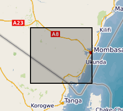
The dataset contains climate data (Humidity, Rainfall, Rainfall Rate, Dewpoint, Atmospheric Pressure, Temperature, Wind Direction, Wind Gust, Wind Chill, Solar Radiation, Windspeed, Heat Index, UV & UVI) at daily temporal resolution from Maplin Professional Solar Powered Wi-Fi Weather Stations installed at Munje and Galu within the study area.