 BGS Data Catalogue
Volcanoes
Type of resources
Topics
Keywords
Contact for the resource
Provided by
Years
Formats
Representation types
Update frequencies
-
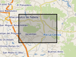
The data is provided as a single spreadsheet containing geochemical information from three volcanoes (Antuco, Chile; Jocotitlan, Mexico; Montserrat), all of which have been affected by major debris avalanches. The data was collected in order to investigate the long-term evolution of these volcanic systems. In addition, a single worksheet is provided of a summary database of published examples of volcanic debris avalanches. The geochemical data include bulk-rock XRF and ICP-MS data, Sr and Pb isotope measurements, and glass analyses for the Montserrat samples, along with site information for Antuco and Jocotitlan. Additional published analyses for Montserrat is availabile in published papers, as detailed in the spreadsheet.
-
Whole-rock geochemistry data of samples collected from Tindfjallajökull volcano, south Iceland. For further information, see Moles, J. D. (2018). Volcanic archives of past glacial environments: Tindfjallajökull volcano, Iceland. PhD thesis, The Open University. http://oro.open.ac.uk/id/eprint/62117. Geographical extent: Bounding box latitude and longitude: SW corner 63°42'N 19°46'W and NE corner 63°50'N 19°28'W.
-
Acoustic emissions (AE) and ultrasonic wave velocity data recorded during a series of high temperature thermal cracking experiments by Daoud et al., in the Rock and Ice Physics Laboratory of the University College London. The data gives the time and magnitude of AE output which were recorded contemporaneously whilst cyclically heating three rock types (A Slaufrudalur Granophyre, A Santorini Andesite and a Seljadalur Basalt). The ultrasonic wave velocity data was recorded pre- and post- heating. The data acquisition was permitted using a rock placed within an acoustic wave guide placed inside a high temperature furnace.
-

Whole rock analyses (presented in parts per million, ppm) of volcanic samples from Mt. St Helens, Washington, USA. Detailed sample descriptions and given in Blundy et al. (2008) and references therein. All samples were analysed using solution ICP-MS at the Open University. Blundy, J., Cashman, K.V. and Berlo, K. (2008) Evolving magma storage conditions beneath Mount St. Helens inferred from chemical variations in melt inclusions from the 1980-1986 and current (2004-2006) eruptions, in: Sherrod, D.R., Scott, W.E., Stauffer, P.H. (Eds.), A volcano rekindled: the renewed eruption of Mount St. Helens, 2004-2006, Reston, VA, pp. 755-790.
-
Microgravity data collected at Uturuncu Volcano located in the Altiplano-Puna Volcanic Complex, central Andes, in November 2022. Raw data collected along a survey line spanning from Laguna Colorada to Laguna Verde using a field gravimeter. All data have been preprocessed and corrected for tidal and drift effects. Data are reported with respect to reference station UBAS located to the west of Uturuncu near the Laguna Colorada.
-
RINEX files of GPS observations obtained in the Uturuncu volcano and surroundings (Altiplano-Puna Deformation Anomaly) during the November 2018 and November 2022 campaigns. In the 2018 and 2022 campaigns, 8 and 10 GPS stations have been installed respectively to help constrain the temporal deformation at Uturuncu volcano. The data contains the GNSS observations made in the 2018 campaign at the stations of Depeche Mode (DEMO), Foo Fighters (FOOF), Jimmy (JIMY), Led Zeppelin (LDZP), Metallica (MTLC), Sex Pistols (SEXP), UBQ4 and UTU Base (UBAS) In the 2022 campaign at the stations of Depeche Mode (DEMO), Foo Fighters (FOOF), IGGY, Jimmy (JIMY), Led Zeppelin (LDZP), Metallica (MTLC), Nirvana (NRVN), Offspring (OFSP), Sex Pistols (SEXP) and UTU Base (UBAS) The following devices were used to obtain these data: -Receiver Leica GR30 (serial numbers 1705008, 1705617 and 1705619) -Antenna Leica AS10 (serial numbers 16071044 and 16151018) -Integrate antenna + receiver Topcon Hiper Pro (serial numbers 326-1106 and 342-0370) -Masts "Nysiros style" and UNAVCO single pin + masts. The duration of data collection ranges from 1 day to 6 days depending on the site of the collection.
-
Laser ablation (LA) ICP-MS analyses (presented in parts per million, ppm) of melt inclusions from the 1980 eruption of Mt. St. Helens (18th May-16th October). Detailed sample collection methods are given in Blundy et al. (2008). Blundy, J., Cashman, K.V. and Berlo, K. (2008) Evolving magma storage conditions beneath Mount St. Helens inferred from chemical variations in melt inclusions from the 1980-1986 and current (2004-2006) eruptions, in: Sherrod, D.R., Scott, W.E., Stauffer, P.H. (Eds.), A volcano rekindled: the renewed eruption of Mount St. Helens, 2004-2006, Reston, VA, pp. 755-790.
-

Here, we provide data corresponding to the experimental conditions used, the results gained via electron microprobe for natural and experimental volcanic samples. Mass balance calculations and a compilation of monitoring data for recent explosive eruptions.
-
The Investigating Geophysical Unrest at Sierra NegrA (IGUANA) experiment was designed to monitor seismic activity associated with magmatic unrest at Sierra Negra volcano, Galapagos Islands, Ecuador. In late 2017, it was apparent that Sierra Negra was likely approaching a new eruption, and that the volcanic edifice was critically stressed. The experiment captured seismic broadband data during the final approach to eruption, the eruption onset on 26 June 2018, and co-eruptive deflation.
-

This dataset (1.5 GB) comprises SO2 emission data (SO2 camera and DOAS) of parts of the active 2013 phase from Colima, as well as Scanning electron microscope (SEM) images and microprobe data of the collected ash from explosions and lava and dome rock. These data were used in the following paper: Cassidy, M., Cole, P.D., Hicks, K.E., Varley, N.R., Peters, N., Lerner, A. 'Rapid and slow: Varying ascent rates as a mechanism for Vulcanian explosions' Earth and Planetary Science Letters. 420: 73-84. doi:10.1016/j.epsl.2015.03.025