 BGS Data Catalogue
Methane
Type of resources
Topics
Keywords
Contact for the resource
Provided by
Years
Formats
Representation types
Update frequencies
Scale
-

This dataset is of laboratory ultrasonic shear wave measurements during methane hydrate formation in water saturated Berea sandstone using pulse echo method. We formed methane hydrate and took shear wave measurements during the formation process at different time interval. The hydrate saturation was calculated from measured pressure and temperature changes. This data set was used to show how shear wave velocity and attenuation can be used to estimate permeability of hydrate-bearing geological formations. We observed that velocity and attenuation both increase with hydrate saturation, with two peaks in attenuation at hydrate saturations of around 6% and 20% that correspond to changes in gradient of velocity. These laboratory experiments were conducted in National Oceanography Centre, Southampton by Sourav Sahoo with technical support provided by Laboratory Manager Laurence North. Sourav Sahoo interpreted the data. The hydrate formation process continued for few days and measurements were done mostly during daytime due to limited laboratory access during the night. This data set has been used for the paper published in Journal of Geophysical Research: Solid Earth (DOI 10.1029/2021JB022206)
-

During the drilling of an exploration well in the 1960s, an underground blowout occurred near Sleen, The Netherlands. During approximately 25 months, near-continuous leakage of large amounts of natural gas was released into the subsurface. After the blowout, the local drinking water production company installed a network of groundwater monitoring wells to monitor for possible adverse effects on groundwater quality at the blowout site. Today, more than 50 years after the blowout, the groundwater is still impaired. Data has been correlated with previously published data by Schout et al. (2018) covering description of geology and well depths. During two fieldtrips (November 2019 & October 2020) water samples were collected from several wells covering: - Bulk gas compositions (methane, ethane, propane, oxygen, nitrogen, CO2, Argon). Bulk isotope compositions of methane (δ13C & δH), carbon dioxide (δ13C) and nitrogen (δ15N). - Methane clumped isotope compositions (ΔCD & ΔDD). - Inorganic parameters (hydrocarbons, anions, cations, DOC, alkalinity, nitrate and ammonium). The dataset was created within SECURe project (Subsurface Evaluation of CCS and Unconventional Risks) - https://www.securegeoenergy.eu/. This project has received funding from the European Union’s Horizon 2020 research and innovation programme under grant agreement No 764531.
-
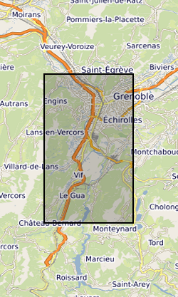
The Fontaine Ardente (FA) and Rochasson (ROC) natural gas seepage sites are located southwest (FA) and east (ROC) of Grenoble, France. For both field sites, gas is thought to originate from buried Middle Jurassic mudstones and argillaceous limestones and thought to migrate upward along small faults. At FA, the site located along a small seepage close to the river bed of a small creek. The gas seepage site at ROC is located along the flank of a thalweg and is linked to a small landslide in clayey horizons. New methane clumped isotope data is correlated to previously published data by Gal et al (2017) and recent isotopic data acquired within SECURe deliverable 3.4. During October 2019, 5 samples were collected from the FA and ROC sites and the following analyses were conducted: - Gas composition (C1-C5, CO2, N2, H2S, Ar) and and stable isotope analyses (methane δ13C and δD, CO2 δ13C, δ15N) - Methane clumped isotope analyses (Δ13CD and ΔDD) The dataset was created within SECURe project (Subsurface Evaluation of CCS and Unconventional Risks) - https://www.securegeoenergy.eu/. This project has received funding from the European Union’s Horizon 2020 research and innovation programme under grant agreement No 764531
-
Raw CO2 and CH4 concentration data from a Picarro Cavity Ring Down Spectroscopy (CRDS) during experiments which tested the utility of methane as a tracer to quantify CO2 leakage into aqueous environments, as described in Myers, M., Roberts, J.J., White, C., and Stalker, L (2019) ‘An experimental investigation into quantifying CO2 leakage in aqueous environments using chemical tracers’ Chemical Geology
-
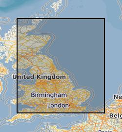
This dataset contains dissolved methane concentrations from groundwater in Great Britain, predominantly from England. Data were collated in Microsoft Excel (.xlsx) format from four publicly accessible sources: the British Geological Survey (from Bell et al., 2017), the Environment Agency for England (from the online Water Quality Archive), and local baseline data for the shale gas sites of Preston New Road (from Cuadrilla Resources) and Kirby Misperton (from Third Energy). In total, 2997 dissolved methane concentrations are included in the dataset and were collected from 922 unique locations from October 1992 to July 2018. The data were used within a Bayesian framework to create a dynamic baseline (a baseline that can change in time and space to reflect ongoing environmental change) that can predict the probability that a change in dissolved methane concentration has occurred, for example in the context of monitoring aquifers at shale gas sites using hydraulic fracturing methods. The data presented are the underlying dataset to Wilson et al., 2020, Science of the Total Environment: https://doi.org/10.1016/j.scitotenv.2019.134854. Bell, R. A., Darling, W. G., Ward, R. S., Basava-Reddi, L., Halwa, L., Manamsa, K., & Dochartaigh, B. Ó. (2017). A baseline survey of dissolved methane in aquifers of Great Britain. Science of the Total Environment, 601, 1803-1813. Wilson, M. P., Worrall, F., Davies, R. J., & Hart, A. (2020). A dynamic baseline for dissolved methane in English groundwater. Science of The Total Environment, 711, 134854.
-

The Borzęcin natural gas reservoir has been producing gas since the 1970s. The natural gas reservoir is located in the Zielona Góra basin, in the Polish part of the European Permian Basin. The reservoir is within the Rotligend sandstones and Zechstein carbonates and is capped by the Zechstein evaporites. Gas generation is proposed to be from the Carboniferous organic deposits with later migration into the Permian In May 2019, 2 wells at the Borcezin site were sampled for methane gas analyses. The following analyses were conducted: - Gas composition (C1-C5, CO2, N2, H2S, Ar) and and stable isotope analyses (methane δ13C and δD, CO2 δ13C, δ15N) - Methane clumped isotope analyses (Δ13CD and ΔDD) The dataset was created within SECURe project (Subsurface Evaluation of CCS and Unconventional Risks) - https://www.securegeoenergy.eu/. This project has received funding from the European Union’s Horizon 2020 research and innovation programme under grant agreement No 764531
-

The dataset contains details of field collection of groundwater samples with use of different water intake devices and the measurement results of gaseous compounds (methane) obtained during analytical method validation performed in order to develop a methodology of groundwater sampling for analysis of dissolved gases. The dataset is not intended to be used for any site characterisation. Sampling sites were chosen based on high probability of occurrence of measureable methane content in groundwater. Furthermore, the data will be used for formal procedure to obtain the methodology accreditation from the Polish Centre for Accreditation (PCA). The dataset was created within SECURe project (Subsurface Evaluation of CCS and Unconventional Risks) - https://www.securegeoenergy.eu/. This project has received funding from the European Union’s Horizon 2020 research and innovation programme under grant agreement No 764531
-
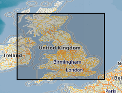
The UK contains extensive resources of coal, both at surface and in the subsurface. It is estimated that onshore these surface and subsurface deposits cover an area of approximately 40,000 km2. This dataset is derived from a 2004 study to assess the potential of the UK onshore coal resources for both exploitation by conventional (mining) and new technologies. Digital data was created using a Geographic Information System (GIS) to produce the delivered output of the original project, a series of paper maps that would identify prospective areas. The dataset layers include: Mining Technologies: Area with technical potential for opencast workings (source Coal Resource Map of Great Britain BGS/Coal Authority 1999) Underground mining exploration prospects Good prospects for abandoned mine methane (AMM) (Mine workings not recovered) Resource area for coal mine methane (CMM) (source Coal Authority Underground Licences, May 2002) Extent of underground workings with 500m buffer zone (based on Coal Authority data, May 2002) New Technologies: Area greater than 1200m from surface with potential for CO2 sequestration Area with good coalbed methane (CBM) potential Underground coal gasification (UCG) potential Coalbed methane (CBM) resource area Coal-bearing strata