 BGS Data Catalogue
Lakes
Type of resources
Topics
Keywords
Contact for the resource
Provided by
Years
Formats
Update frequencies
-
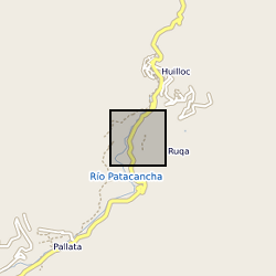
Concentration and accumulation palaeoenvironmental proxy data derived from a 6.3m sedimentary core drilled at Marcacocha, a present-day wetland (formerly a small lake) located at 3355m above sea-level in the Cordillera Oriental of the Peruvian Andes. Multi-proxy analysis of the sediments at decadal to sub-decadal temporal resolution has provided detailed datasets that include sedimentology, palynology, geochemistry, plant macrofossils, diatoms and oribatid mite remains (Chepstow-Lusty et al., 2003, 2007, 2009; Sterken et al., 2006). Select data are presented here relating to the uppermost 1.9m of the sequence (ca. the last 1200 years). The data relate specifically to: Chepstow-Lusty, A., Frogley, M.R., Baker, A.S. Comparison of Sporormiella dung fungal spores and oribatid mites as indicators of large herbivore presence: evidence from the Cuzco region of Peru. J. Arch. Sci. https://doi.org/10.1016/j.jas.2018.12.006 Chepstow-Lusty, A., Bennett, K., Fjeldså, J., Kendall, A., Galiano, W., Tupayachi Herrera, A., 1998. Tracing 4000 years of environmental history in the Cuzco area, Peru, from the pollen record. Mt. Res. Dev. 18, 159–172. Chepstow-Lusty, A., Frogley, M.R., Bauer, B.S., Bush, M.B., Tupayachi Herrera, A., 2003. A late Holocene record of arid events from the Cuzco region, Peru. J. Quat. Sci. 18, 491–502. Chepstow-Lusty, A., Frogley, M.R., Bauer, B.S., Leng, M., Cundy, A., Boessenkool, K.P., Gioda, A., 2007. Evaluating socio-economic change in the Andes using oribatid mite abundances as indicators of domestic animal densities. J. Arch. Sci. 34, 1178–1186. Chepstow-Lusty, A.J., Frogley, M.R., Bauer, B., Leng, M.J., Boessenkool, K.P., Carcaillet, C., Ali, A.A., Gioda, A., 2009. Putting the rise of the Inca empire within a climatic and land management context. Clim. Past 5, 1–14. Sterken, M., Sabbe, K., Chepstow-Lusty, A., Frogley, M., Vanhoutte, K., Verleyen, E., Cundy, A., Vyverman, W., 2006. Climate and land-use changes in the Cuzco region (Cordillera Oriental, South East Peru) during the last 1200 years: a diatom based reconstruction. Arch. Hydrobiol. 165, 289–312.
-
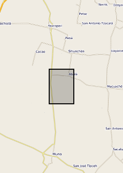
Surface waters and shallow groundwater samples were collected by completely filling 30 mL polyethylene bottles, which were then sealed with electrical tape to minimise the risk of evaporative loss. Rainwater samples were integrated samples of total monthly rainfall collected in a specially-adapted rainfall collector following IAEA protocols (IAEA http://www-naweb.iaea.org/napc/ih/documents/userupdate/sampling.pdf [accessed 22 June 2012). Mexico, State of Yucatan. Yaal Chac (lake) (lake centre is Lat: 20.595274 degrees; Long: -89.711301 degrees), Abala Well (Lat: 20.649044 degrees; Long: -89.679814 degrees) and Xanil ha Cave (Lat: 20.650809 degrees; Long: -89.697426 degrees) Rainwater sampler was located adjacent to the lake. Refer to accompanying map for the precise location of the sampling sites.