 BGS Data Catalogue
Hydrocarbons
Type of resources
Topics
Keywords
Contact for the resource
Provided by
Years
Formats
Representation types
Update frequencies
Scale
-
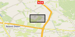
On December 1, 1965, an underground blowout during an exploratory drill with a catastrophic outcome occurred near Sleen, The Netherlands. During approximately 2.5 months, near-continuous leakage of large amounts of natural gas was released into the subsurface. After the blowout, the local drinking water production company installed a network of groundwater monitoring wells to monitor for possible adverse effects on groundwater quality at the blowout site. Today, more than 50 years after the blowout, the groundwater is still impaired. Data has been correlated with previously published data by Schout et al. (2018) covering description of geology and well depths. During October 2019 we sampled from 12 groundwater wells covering: - Inorganic parameters (hydrocarbons, anions, cations, DOC, alkalinity, nitrate and ammonium) - DNA (quantification of total bacteria by qPCR 16S, aerobic methane oxidation by qPCR pmoA, and anaerobic methane oxidation by qPCR mcrA) The dataset was created within SECURe project (Subsurface Evaluation of CCS and Unconventional Risks) - https://www.securegeoenergy.eu/. This project has received funding from the European Union’s Horizon 2020 research and innovation programme under grant agreement No 764531
-

High level index to the contents of the boxes of Primary Geological Data resulting from deep underground coal exploration and exploitation in Great Britain donated by the Coal Authority in July 2001. Data for past and current collieries and for future prospects including borehole site plans, borehole logs , analyses and geophysical data etc. This index will diminish in importance as these data are merged with existing collections.
-

Collection of reports, interpretations and records of research in British coalfield areas deposited by British Coal. Data for past and current collieries and for future prospects. Some 1000 linear feet (300m) of data. Information within the reports date from the 19th Century up to the present day.
-
Prime Geological Data resulting from deep underground coal exploration and exploitation produced by the British Coal Board and/or its precursors. The collection dates back to the 18th century and covers all the British coal mining areas and includes borehole site plans, borehole logs, analyses and geophysical data etc. Apart from primary data relating to past and current collieries and for future prospects the information includes reports, interpretations and records of research. The majority of the collection was deposited with the National Geological Records Centre by the Coal Authority in July 2001.
-

The BGS collection of paper and sepia geophysical logs from boreholes drilled by BGS and external organisations. The majority of the collection are in hard copy , but significant numbers are now available digitally. Covering the UK mainland and offshore from 1949 onwards. the commercial logs are mainly related to hydrocarbon , coal exploration or water wells. The collection covers Great Britain and the types of logs and the scales used will vary depending on the equipment available and the use of the data.
-
Index, set up in 1998, to the archive collection of reports, notebooks interpretations, plans and other geological or related data received from external organisations that are not part of other collections. These cover a wide variety of different types and ages of information mainly from Great Britain but some related to BGS projects overseas.
-

The Index to the Primary Geological Data resulting from Open Cast Coal exploration. The index lists the content of the boxes of data, including reports, interpretations and records of research in British coalfield areas. The Index lists information on past and current workings and for future prospects. The majority of the collection was deposited with the National Geological Records Centre by the Coal Authority in July 2001, but a small number of BGS records have been added subsequently.
-

Data resulting from deep underground coal exploration and exploitation. Collection of data, dating back to the 18th century, includes reports, interpretations and records of research in all British coalfield areas deposited by the British Coal Corporation. Data for past and current collieries and for future prospects. The majority of the collection was deposited with the National Geological Records Centre in July 2001. The collection includes borehole site plans, borehole logs , analyses and geophysical data etc. Records were selected for retention by British Coal Surveyors and BGS.
-

This layer of the map based index (GeoIndex) shows the location of hydrocarbon wells known to BGS. Exploration for hydrocarbons by drilling began in the 19th century and locations were recorded in latitude/longitude until about 1960. These locations have been converted to national grid. The majority of the wells have formed part of basin studies by BGS and are therefore reliably located. There may be some discrepancies in location data between various databases, originating from project modifications and which original source was preferred.
-

Data from onshore wells provided to BGS as part of an agreement with NSTA/OGA/DECC Digital data (includes, well logs, well reports and downhole data) for oil and gas exploration and appraisal wells drilled in the UK and held on behalf of the North Sea Transitory Authority (formerly the Oil & Gas Authority, formerly the Department of Energy and Climate Change). External data therefore BGS has no control on quality. Provided to OGA/DECC/BGS by oil companies as part of their obligations under licensing regulations, PON 9b regulations notice.