 BGS Metadata Catalogue
Radiocarbon measurements on foraminifera from sediment cores in the North Atlantic (NERC Grant NE/M004619/1, NE/M003434/1)
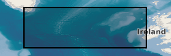
Radiocarbon measurements on planktic and benthic foraminifera from sediment cores in the North Atlantic: Ocean Drilling Program (ODP) 983, SU90-44, MD04-2829, MD01-2461, and EW9302-2JPC Site 983 is located on the Bjorn Drift in approximately 1650 m water depth on the eastern flank of the Reykjanes Ridge. Hole 983A Position: 60°24.200'N, 23°38.437'W. Sediment core SU90-44 collected from the north-eastern Atlantic basin, near the top of a small abyssal hill, southeast of the Rockall plateau, 50°01'N, 17°06'W, 4279 m. Sediment core MD04-2829 collected from Rosemary Bank in the Northern Rockall Trough 58º 56.93’ N; 09º 34.30’ W; 1743 m water depth. Sediment core MD01-2461 was collected from the north-western flank of the Porcupine Seabight approximately 550 km to the southwest, 51°45’N, 12°55’W; 1153 m water depth, recovered in 2001. Core EW9302-2JPC recovered from the Rockall Plateau and East Flank of Reykjanes Ridge from the Flemish Cap in the south- eastern Labrador Sea, 48°47.70′N, 45°05.09′W, taken at water depth 1251m.
Simple
- Date (Creation)
- 2023-03-01
- Citation identifier
- http://data.bgs.ac.uk/id/dataHolding/13608047
- Point of contact
-
Organisation name Individual name Electronic mail address Role University of St Andrews
Andrea Burke
not available
Originator British Geological Survey
Enquiries
not available
Distributor British Geological Survey
Enquiries
not available
Point of contact
- Maintenance and update frequency
- notApplicable
-
GEMET - INSPIRE themes, version 1.0
- dataCentre
- Keywords
-
-
NERC_DDC
-
- Access constraints
- Other restrictions
- Other constraints
- restricted
- Use constraints
- Other restrictions
- Other constraints
-
The copyright of materials derived from the British Geological Survey's work is vested in the Natural Environment Research Council [NERC]. No part of this work may be reproduced or transmitted in any form or by any means, or stored in a retrieval system of any nature, without the prior permission of the copyright holder, via the BGS Intellectual Property Rights Manager. Use by customers of information provided by the BGS, is at the customer's own risk. In view of the disparate sources of information at BGS's disposal, including such material donated to BGS, that BGS accepts in good faith as being accurate, the Natural Environment Research Council (NERC) gives no warranty, expressed or implied, as to the quality or accuracy of the information supplied, or to the information's suitability for any use. NERC/BGS accepts no liability whatever in respect of loss, damage, injury or other occurence however caused.
- Other constraints
-
Either: (i) the dataset is made freely available, e.g. via the Internet, for a restricted category of use (e.g. educational use only); or (ii) the dataset has not been formally approved by BGS for access and use by external clients under licence, but its use may be permitted under alternative formal arrangements; or (iii) the dataset contains 3rd party data or information obtained by BGS under terms and conditions that must be consulted in order to determine the permitted usage of the dataset. Refer to the BGS staff member responsible for the creation of the dataset if further advice is required. He / she should be familiar with the composition of the dataset, particularly with regard to 3rd party IPR contained in it, and any resultant use restrictions. This staff member should revert to the IPR Section ( ipr@bgs.ac.uk) for advice, should the position not be clear.
- Spatial representation type
- Vector
- Language
- English
- Topic category
-
- Geoscientific information
))
- Begin date
- 2015-05-04
- End date
- 2020-09-30
- Unique resource identifier
- WGS 84 (EPSG::4326)
- Distribution format
-
Name Version Microsoft Excel
witheld
- Distributor contact
-
Organisation name Individual name Electronic mail address Role British Geological Survey
Enquiries
not available
Distributor
- OnLine resource
-
Protocol Linkage Name WWW:DOWNLOAD-1.0-http--download
https://webapps.bgs.ac.uk/services/ngdc/accessions/index.html#item177828 Data
- Hierarchy level
- Dataset
- Other
-
dataset
Conformance result
- Title
-
INSPIRE Implementing rules laying down technical arrangements for the interoperability and harmonisation of Geology
- Date (Publication)
- 2011
- Explanation
-
See the referenced specification
- Pass
- No
Conformance result
- Title
-
Commission Regulation (EU) No 1089/2010 of 23 November 2010 implementing Directive 2007/2/EC of the European Parliament and of the Council as regards interoperability of spatial data sets and services
- Date (Publication)
- 2010-12-08
- Explanation
-
See http://eur-lex.europa.eu/LexUriServ/LexUriServ.do?uri=OJ:L:2010:323:0011:0102:EN:PDF
- Pass
- No
- Statement
-
Pre-treatment of the foraminifera specimens followed the approach by Nadeau et al. (2001). Sample was transferred into a septum sealed vial. Then 200 microlitre of a 15% hydrogen peroxide (H2O2) solution was added and the tube placed in an ultra-sonic bath for ~3min to remove organic surface contaminants and to provide a mild leach of the foraminifera material. Subsequently, hydrogen peroxide was decanted using a fine syringe and rinsed repeatedly in Milli-Q water. While still damp the samples were evacuated and 1 ml of 85% phosphoric acid was added to hydrolyse the samples to CO2 at 70°C until complete dissolution. Samples were then converted into graphite on a Fe catalyst using the hydrogen reduction method (Vogel et al., 1987) for AMS analysis at the Queens University Belfast AMS facility.
Metadata
- File identifier
- f6f198b0-b40b-4a51-e053-0937940a7548 XML
- Metadata language
- English
- Hierarchy level
- Dataset
- Date stamp
- 2026-07-11
- Metadata standard name
- UK GEMINI
- Metadata standard version
-
2.3
- Metadata author
-
Organisation name Individual name Electronic mail address Role British Geological Survey
Point of contact
- Dataset URI
)))
