 BGS Metadata Catalogue
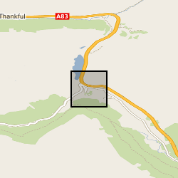
Time lapse camera imagery A83 Rest and Be Thankful (NERC Grant NE/T00567X/1)
Fixed time lapse camera imagery with 15 minute interval during daytimes captured from Ben Donich (BNG: NN 2297 0637) looking towards the A83 Rest and Be Thankful / slope of Beinn Luibhean. Data were subsequently processed in https://doi.org/10.3390/rs13050893 for deformation tracking. There are data gaps during poor weather/outages, and, some camera shift requiring alignment .
Simple
- Date (Creation)
- 2022-09-13
- Citation identifier
- http://data.bgs.ac.uk/id/dataHolding/13607971
- Point of contact
-
Organisation name Individual name Electronic mail address Role University of Newcastle
Stuart Dunning
not available
Originator British Geological Survey
Enquiries
not available
Distributor British Geological Survey
Enquiries
not available
Point of contact
- Maintenance and update frequency
- notApplicable
-
GEMET - INSPIRE themes, version 1.0
-
BGS Thesaurus of Geosciences
-
-
Landslides
-
Photography
-
- dataCentre
- Keywords
-
-
NERC_DDC
-
- Access constraints
- Other restrictions
- Other constraints
- no limitations
- Other constraints
- The dataset is made freely available for access, e.g. via the Internet. Either no third party data / information is contained in the dataset or BGS has secured written permission from the owner(s) of any third party data / information contained in the dataset to make the dataset freely accessible.
- Use constraints
- Other restrictions
- Other constraints
-
The copyright of materials derived from the British Geological Survey's work is vested in the Natural Environment Research Council [NERC]. No part of this work may be reproduced or transmitted in any form or by any means, or stored in a retrieval system of any nature, without the prior permission of the copyright holder, via the BGS Intellectual Property Rights Manager. Use by customers of information provided by the BGS, is at the customer's own risk. In view of the disparate sources of information at BGS's disposal, including such material donated to BGS, that BGS accepts in good faith as being accurate, the Natural Environment Research Council (NERC) gives no warranty, expressed or implied, as to the quality or accuracy of the information supplied, or to the information's suitability for any use. NERC/BGS accepts no liability whatever in respect of loss, damage, injury or other occurence however caused.
- Other constraints
-
Available under the Open Government Licence subject to the following acknowledgement accompanying the reproduced NERC materials "Contains NERC materials ©NERC [year]"
- Spatial representation type
- Grid
- Language
- English
- Topic category
-
- Geoscientific information
- Geographic identifier
-
Argyll and Bute [id=30106]
British Geological Survey Gazetteer: OS Boundary Line 2009 revision
))
- Begin date
- 2020-01-01
- End date
- 2022-02-22
- Unique resource identifier
- OSGB 1936 / British National Grid (EPSG::27700)
- Distribution format
-
Name Version Image (JPEG)
- Distributor contact
-
Organisation name Individual name Electronic mail address Role British Geological Survey
Enquiries
not available
Distributor
- OnLine resource
-
Protocol Linkage Name WWW:DOWNLOAD-1.0-http--download
https://webapps.bgs.ac.uk/services/ngdc/accessions/index.html#item175924 Data
- Hierarchy level
- Dataset
- Other
-
dataset
Conformance result
- Title
-
INSPIRE Implementing rules laying down technical arrangements for the interoperability and harmonisation of Geology
- Date (Publication)
- 2011
- Explanation
-
See the referenced specification
- Pass
- No
Conformance result
- Title
-
Commission Regulation (EU) No 1089/2010 of 23 November 2010 implementing Directive 2007/2/EC of the European Parliament and of the Council as regards interoperability of spatial data sets and services
- Date (Publication)
- 2010-12-08
- Explanation
-
See http://eur-lex.europa.eu/LexUriServ/LexUriServ.do?uri=OJ:L:2010:323:0011:0102:EN:PDF
- Pass
- No
- Statement
-
15 minute interval full-frame camera housed in a Cyclapse and then Bixi box housing with glass front at BNG: NN 2297 0637 shooting in auto exposure/shutter speed. All shot parameters including camera and lens are stored in the EXIF data in each jpeg image. All images are 'as shot' with no processing or alignment to account for camera shift.
Metadata
- File identifier
- e9300391-4095-6ebe-e053-0937940a8db2 XML
- Metadata language
- English
- Hierarchy level
- Dataset
- Date stamp
- 2026-07-11
- Metadata standard name
- UK GEMINI
- Metadata standard version
-
2.3
- Metadata author
-
Organisation name Individual name Electronic mail address Role British Geological Survey
Point of contact
- Dataset URI
)))
