 BGS Metadata Catalogue
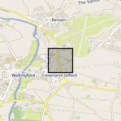
High resolution river stage and groundwater level data from Wallingford, Oxfordshire, UK
The borehole is located at the UK Centre for Ecology and Hydrology (UKCEH), screened between 2 and 4.5 m in the Thames gravels, and drilled to a total depth of 4.8m. It is located on an actively managed grass verge with popular and sycamore trees within 10 m. The stilling well is positioned 420 m west of the borehole in the River Thames. Both stage and groundwater level were monitored at 1-minutre frequency to investigate hydrological fractal scaling of high frequency data between 2012 and 2016. An automatic weather station is present between the borehole and stilling well and the data are available separately from UKCEH ( stetur@ceh.ac.uk). Further site description is provided in: Habib, A. et al. 2017. Journal of Hydrology, 549, 715-730. Habib, A. et al. 2022. Hydrological Sciences Journal
Simple
- Date (Creation)
- 2022-05-31
- Citation identifier
- http://data.bgs.ac.uk/id/dataHolding/13607938
- Point of contact
-
Organisation name Individual name Electronic mail address Role British Geological Survey
Enquiries
Distributor British Geological Survey
Enquiries
Originator British Geological Survey
Enquiries
Point of contact
- Maintenance and update frequency
- Not planned
-
GEMET - INSPIRE themes, version 1.0
-
BGS Thesaurus of Geosciences
-
-
Gravel
-
Groundwater
-
Aquifers
-
- dataCentre
- Keywords
-
-
NERC_DDC
-
- Access constraints
- Other restrictions
- Other constraints
- licenceOGL
- Use constraints
- Other restrictions
- Other constraints
-
The copyright of materials derived from the British Geological Survey's work is vested in the Natural Environment Research Council [NERC]. No part of this work may be reproduced or transmitted in any form or by any means, or stored in a retrieval system of any nature, without the prior permission of the copyright holder, via the BGS Intellectual Property Rights Manager. Use by customers of information provided by the BGS, is at the customer's own risk. In view of the disparate sources of information at BGS's disposal, including such material donated to BGS, that BGS accepts in good faith as being accurate, the Natural Environment Research Council (NERC) gives no warranty, expressed or implied, as to the quality or accuracy of the information supplied, or to the information's suitability for any use. NERC/BGS accepts no liability whatever in respect of loss, damage, injury or other occurence however caused.
- Other constraints
-
There are no restrictions on the use that may be made of the dataset, although an appropriate copyright acknowledgement must be made when any part of the dataset is reproduced. Either no third party data / information is contained in the dataset or BGS has secured written permission from the owner of any third party data / information contained in the dataset to make the dataset freely available without any use constraints - inclusion of any third party data / information will affect the copyright acknowledgement that needs to be made.
- Spatial representation type
- Vector
- Language
- English
- Topic category
-
- Geoscientific information
- Geographic identifier
-
Wallingford [id=1438017]
British Geological Survey Gazetteer: OS gazetteer 2002 revision
))
- Begin date
- 2012-01-02
- End date
- 2016-12-31
- Unique resource identifier
- OSGB 1936 / British National Grid (EPSG::27700)
- Distribution format
-
Name Version Microsoft Excel
witheld
- Distributor contact
-
Organisation name Individual name Electronic mail address Role British Geological Survey
Enquiries
Distributor
- OnLine resource
-
Protocol Linkage Name WWW:LINK-1.0-http--link
https://www.bgs.ac.uk/ BGS Homepage
- Hierarchy level
- Dataset
- Other
-
dataset
Conformance result
- Title
-
INSPIRE Implementing rules laying down technical arrangements for the interoperability and harmonisation of Geology
- Date (Publication)
- 2011
- Explanation
-
See the referenced specification
- Pass
- No
Conformance result
- Title
-
Commission Regulation (EU) No 1089/2010 of 23 November 2010 implementing Directive 2007/2/EC of the European Parliament and of the Council as regards interoperability of spatial data sets and services
- Date (Publication)
- 2010-12-08
- Explanation
-
See http://eur-lex.europa.eu/LexUriServ/LexUriServ.do?uri=OJ:L:2010:323:0011:0102:EN:PDF
- Pass
- No
- Statement
-
Data were collecting using KPSI 501 pressure transducers and were converted to mAOD (Meters above ordnance datum) and validated using manual dip measurements.
Metadata
- File identifier
- e061f6a7-a6d8-79c2-e053-0937940a9c2a XML
- Metadata language
- English
- Hierarchy level
- Dataset
- Date stamp
- 2026-07-10
- Metadata standard name
- UK GEMINI
- Metadata standard version
-
2.3
- Metadata author
-
Organisation name Individual name Electronic mail address Role British Geological Survey
Point of contact
- Dataset URI
)))
