 BGS Metadata Catalogue
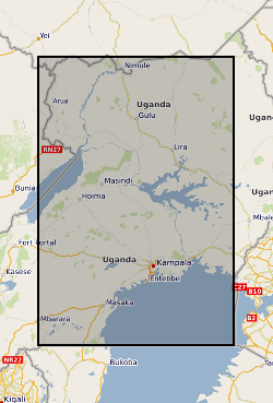
Borehole and transmissivity dataset, Uganda (NERC Grant NE/M008606/1) - superseded
Revised dataset available here http://data.bgs.ac.uk/id/dataHolding/13607942 .This dataset comprises 655 borehole records and previously unanalysed pumping tests from across Uganda that were compiled from historical borehole records held within 9 district water offices. The dataset is a compilation of historical borehole records held within nine district water offices across Uganda. These data originated from numerous drilling campaigns undertaken by private contractors in each district to site and construct hand-pump borehole community water supplies between 2000 to 2018. In total over 1000 paper borehole records were initially collated and reviewed. This work was carried out over several months visiting the district water offices. Following a quality assurance procedure 655 records were transcribed to create a digital dataset. Each borehole record in the dataset contains a series of metadata alongside the pumping test data (e.g. pump depth, static water level, pumping rate and duration) including locational information (e.g. coordinates, water strike, borehole depth, borehole lithologies). The dataset is delivered as a series georeferenced site information within an MS Excel spreadsheet file.
Simple
- Date (Creation)
- 2022-01-20
- Citation identifier
- http://data.bgs.ac.uk/id/dataHolding/13607897
- Point of contact
-
Organisation name Individual name Electronic mail address Role University College London
Professor Richard Taylor
not available
Originator Makerere University
Michael Owor
not available
Originator Makerere University
Joseph Okullo
not available
Originator British Geological Survey
Enquiries
Distributor British Geological Survey
Enquiries
Originator British Geological Survey
Enquiries
Principal investigator British Geological Survey
Enquiries
not available
Distributor British Geological Survey
Enquiries
not available
Originator British Geological Survey
Enquiries
not available
Point of contact
- Maintenance and update frequency
- notApplicable
-
GEMET - INSPIRE themes, version 1.0
-
BGS Thesaurus of Geosciences
-
-
Transmissivity
-
Boreholes
-
Groundwater
-
- dataCentre
- Keywords
-
-
NERC_DDC
-
- Access constraints
- Other restrictions
- Other constraints
- licenceOGL
- Use constraints
- Other restrictions
- Other constraints
-
The copyright of materials derived from the British Geological Survey's work is vested in the Natural Environment Research Council [NERC]. No part of this work may be reproduced or transmitted in any form or by any means, or stored in a retrieval system of any nature, without the prior permission of the copyright holder, via the BGS Intellectual Property Rights Manager. Use by customers of information provided by the BGS, is at the customer's own risk. In view of the disparate sources of information at BGS's disposal, including such material donated to BGS, that BGS accepts in good faith as being accurate, the Natural Environment Research Council (NERC) gives no warranty, expressed or implied, as to the quality or accuracy of the information supplied, or to the information's suitability for any use. NERC/BGS accepts no liability whatever in respect of loss, damage, injury or other occurence however caused.
- Other constraints
-
Available under the Open Government Licence subject to the following acknowledgement accompanying the reproduced NERC materials "Contains NERC materials ©NERC [year]"
- Spatial representation type
- Vector
- Language
- English
- Topic category
-
- Geoscientific information
- Geographic identifier
-
UG
ISO 3166_1 alpha-2 2009 revision
- Geographic identifier
-
UGA
ISO 3166_1 alpha-3 2009 revision
- Geographic identifier
-
UGANDA [id=689000]
British Geological Survey Gazetteer: Geographical hierarchy from Geosaurus 1979 creation
))
- Begin date
- 2019-01-01
- End date
- 2019-10-01
- Unique resource identifier
- WGS 84 (EPSG::4326)
- Distribution format
-
Name Version Microsoft Excel
witheld
- Distributor contact
-
Organisation name Individual name Electronic mail address Role British Geological Survey
Enquiries
Distributor
- Distributor contact
-
Organisation name Individual name Electronic mail address Role British Geological Survey
Enquiries
not available
Distributor
- OnLine resource
-
Protocol Linkage Name WWW:DOWNLOAD-1.0-http--download
https://webapps.bgs.ac.uk/services/ngdc/accessions/index.html#item171476 Data
- OnLine resource
-
Protocol Linkage Name WWW:LINK-1.0-http--related
https://doi.org/10.5285/f99ff6c7-ce82-4011-ac3e-9328d7db3502 Citation Information - Digital Object Identifier (DOI)
- Hierarchy level
- Dataset
- Other
-
dataset
Conformance result
- Title
-
INSPIRE Implementing rules laying down technical arrangements for the interoperability and harmonisation of Geology
- Date (Publication)
- 2011
- Explanation
-
See the referenced specification
- Pass
- No
Conformance result
- Title
-
Commission Regulation (EU) No 1089/2010 of 23 November 2010 implementing Directive 2007/2/EC of the European Parliament and of the Council as regards interoperability of spatial data sets and services
- Date (Publication)
- 2010-12-08
- Explanation
-
See http://eur-lex.europa.eu/LexUriServ/LexUriServ.do?uri=OJ:L:2010:323:0011:0102:EN:PDF
- Pass
- No
- Statement
-
The dataset is a compilation of historical borehole records held within nine district water offices across Uganda. These data originated from numerous drilling campaigns undertaken by private contractors in each district to site and construct hand-pump borehole community water supplies between 2000 to 2018. In total over 1000 paper borehole records were initially collated and reviewed. This work was carried out over several months visiting the district water offices. Following a quality assurance procedure 655 records were transcribed to create a digital dataset.
Metadata
- File identifier
- d67dcc95-97f5-4a25-e054-002128a47908 XML
- Metadata language
- English
- Hierarchy level
- Dataset
- Date stamp
- 2026-07-11
- Metadata standard name
- UK GEMINI
- Metadata standard version
-
2.3
- Metadata author
-
Organisation name Individual name Electronic mail address Role British Geological Survey
Point of contact
- Dataset URI
)))
