 BGS Metadata Catalogue
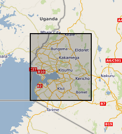
Western Kenya soil geochemistry
Soil prediction maps for 56 chemical elements, pH and organic matter content have been produced using machine learning analysis in western Kenya. The predictive maps were based on 452 soil samples collected across western Kenya during field surveys carried out between 2015 and 2020. Samples were analysed by the inorganic chemistry laboratories at the British Geological Survey. The maps, created using random forest machine learning algorithms, are displayed as raster files with a spatial resolution of 500m. The samples were collected as part of a geochemistry and health project to investigate the spatial incidences of diseases in the Rift Valley (e.g. oesophageal cancer, iodine/zinc deficiency), which included a range of data and sample collections to inform sources of micronutrients or exposure to potentially harmful elements, with outputs to inform agriculture and public health practitioners. These predictive maps provide a baseline geochemistry survey for the agri-community, academics and public health officials.
Simple
- Date (Creation)
- 2021-08
- Citation identifier
- http://data.bgs.ac.uk/id/dataHolding/13607850
- Point of contact
-
Organisation name Individual name Electronic mail address Role University of Eldoret
Odipo Osano
not available
Originator Moi University
Diana Menya
not available
Originator British Geological Survey
Enquiries
Distributor British Geological Survey
Enquiries
Originator British Geological Survey
Enquiries
Point of contact
- Maintenance and update frequency
- As needed
-
GEMET - INSPIRE themes, version 1.0
-
BGS Thesaurus of Geosciences
-
-
Soil maps
-
Geochemistry
-
Soils
-
- dataCentre
- Keywords
-
-
NERC_DDC
-
- Access constraints
- Other restrictions
- Other constraints
- licenceOGL
- Use constraints
- Other restrictions
- Other constraints
-
The copyright of materials derived from the British Geological Survey's work is vested in the Natural Environment Research Council [NERC]. No part of this work may be reproduced or transmitted in any form or by any means, or stored in a retrieval system of any nature, without the prior permission of the copyright holder, via the BGS Intellectual Property Rights Manager. Use by customers of information provided by the BGS, is at the customer's own risk. In view of the disparate sources of information at BGS's disposal, including such material donated to BGS, that BGS accepts in good faith as being accurate, the Natural Environment Research Council (NERC) gives no warranty, expressed or implied, as to the quality or accuracy of the information supplied, or to the information's suitability for any use. NERC/BGS accepts no liability whatever in respect of loss, damage, injury or other occurence however caused.
- Other constraints
-
There are no restrictions on the use that may be made of the dataset, although an appropriate copyright acknowledgement must be made when any part of the dataset is reproduced. Either no third party data / information is contained in the dataset or BGS has secured written permission from the owner of any third party data / information contained in the dataset to make the dataset freely available without any use constraints - inclusion of any third party data / information will affect the copyright acknowledgement that needs to be made.
- Spatial representation type
- Grid
- Language
- English
- Topic category
-
- Geoscientific information
- Geographic identifier
-
KE
ISO 3166_1 alpha-2 2009 revision
- Geographic identifier
-
KEN
ISO 3166_1 alpha-3 2009 revision
- Geographic identifier
-
KENYA [id=687000]
British Geological Survey Gazetteer: Geographical hierarchy from Geosaurus 1979 creation
))
- Begin date
- 2015-01-01
- End date
- 2020-03-31
- Unique resource identifier
- WGS 84 (EPSG::4326)
- Distribution format
-
Name Version Image (TIFF)
- Distributor contact
-
Organisation name Individual name Electronic mail address Role British Geological Survey
Enquiries
Distributor
- OnLine resource
-
Protocol Linkage Name WWW:DOWNLOAD-1.0-http--download
https://webapps.bgs.ac.uk/services/ngdc/accessions/index.html#item169711 Data
- OnLine resource
-
Protocol Linkage Name WWW:LINK-1.0-http--related
https://doi.org/10.5285/bd1f80ef-114a-429d-a629-20d19bacec79 Citation Information - Digital Object Identifier (DOI)
- Hierarchy level
- Dataset
- Other
-
dataset
Conformance result
- Title
-
INSPIRE Implementing rules laying down technical arrangements for the interoperability and harmonisation of Geology
- Date (Publication)
- 2011
- Explanation
-
See the referenced specification
- Pass
- No
Conformance result
- Title
-
Commission Regulation (EU) No 1089/2010 of 23 November 2010 implementing Directive 2007/2/EC of the European Parliament and of the Council as regards interoperability of spatial data sets and services
- Date (Publication)
- 2010-12-08
- Explanation
-
See http://eur-lex.europa.eu/LexUriServ/LexUriServ.do?uri=OJ:L:2010:323:0011:0102:EN:PDF
- Pass
- No
- Statement
-
The soil samples were collected and analysed by the Inorganic Chemistry Facility, University of Eldoret and Moi University during ODA-I (2015-2020) as part of a geochemistry and health project to investigate the spatial incidences of diseases in the Rift Valley. Following the compilation of the soil data BGS undertook random forest machine learning analysis in conjunction with additional open-access environmental covariate datasets to create the geochemical prediction maps.
Metadata
- File identifier
- d171c124-58cf-6e47-e054-002128a47908 XML
- Metadata language
- English
- Hierarchy level
- Dataset
- Date stamp
- 2026-07-10
- Metadata standard name
- UK GEMINI
- Metadata standard version
-
2.3
- Metadata author
-
Organisation name Individual name Electronic mail address Role British Geological Survey
Point of contact
- Dataset URI
)))
