 BGS Metadata Catalogue
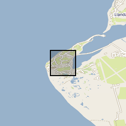
Llanbedr Mochras Farm Core X-ray computed tomography (XCT) scans of consolidated shale from the Lower Jurassic of the Cardigan Bay Basin, Wales (NERC Grant NE/N018559/1)
X-ray computed tomography (XCT) scans of four samples of consolidated shale from the Lower Jurassic (C.exaratum subzone) of the Cardigan Bay Basin (Wales, UK). The samples were taken from the Mochras Core, at depths of 789, 810, 812, and 818m (all samples within data measured in metres). Each sample is distinguished by its unique sample identification number (SSK). For each sample, there is a stack of XCT orthoslices (.tiff) files, and for SSK109633, an incomplete Avizo file. Mochras core location (aprox.) 52°48'39.74"N, 4° 8'48.09"W. Mochras Island, west of Llanbedr, Gwynedd, Wales, UK
Simple
- Date (Creation)
- 2021-09-17
- Citation identifier
- http://data.bgs.ac.uk/id/dataHolding/13607810
- Point of contact
-
Organisation name Individual name Electronic mail address Role University of Leeds
Dr Robert Newton
not available
Principal investigator University of Leeds
Connor O'Keeffe
not available
Originator British Geological Survey
Enquiries
not available
Distributor British Geological Survey
Enquiries
not available
Point of contact
- Maintenance and update frequency
- notApplicable
-
GEMET - INSPIRE themes, version 1.0
-
BGS Thesaurus of Geosciences
-
-
Shale
-
Jurassic
-
- dataCentre
- Keywords
-
-
NERC_DDC
-
- Access constraints
- Other restrictions
- Other constraints
- licenceOGL
- Use constraints
- Other restrictions
- Other constraints
-
The copyright of materials derived from the British Geological Survey's work is vested in the Natural Environment Research Council [NERC]. No part of this work may be reproduced or transmitted in any form or by any means, or stored in a retrieval system of any nature, without the prior permission of the copyright holder, via the BGS Intellectual Property Rights Manager. Use by customers of information provided by the BGS, is at the customer's own risk. In view of the disparate sources of information at BGS's disposal, including such material donated to BGS, that BGS accepts in good faith as being accurate, the Natural Environment Research Council (NERC) gives no warranty, expressed or implied, as to the quality or accuracy of the information supplied, or to the information's suitability for any use. NERC/BGS accepts no liability whatever in respect of loss, damage, injury or other occurence however caused.
- Other constraints
-
Available under the Open Government Licence subject to the following acknowledgement accompanying the reproduced NERC materials "Contains NERC materials ©NERC [year]"
- Spatial representation type
- Grid
- Language
- English
- Topic category
-
- Geoscientific information
- Geographic identifier
-
Llanbedr [id=1340969]
British Geological Survey Gazetteer: OS gazetteer 2002 revision
- Geographic identifier
-
Mochras (Shell Island) [id=1458076]
British Geological Survey Gazetteer: OS gazetteer 2002 revision
))
- End date
- 2021-09-17 Before
- Unique resource identifier
- OSGB 1936 / British National Grid (EPSG::27700)
- Distribution format
-
Name Version Image (TIFF)
- Distributor contact
-
Organisation name Individual name Electronic mail address Role British Geological Survey
Enquiries
not available
Distributor
- OnLine resource
-
Protocol Linkage Name WWW:DOWNLOAD-1.0-http--download
https://webapps.bgs.ac.uk/services/ngdc/accessions/index.html#item168653 Data
- Hierarchy level
- Dataset
- Other
-
dataset
Conformance result
- Title
-
INSPIRE Implementing rules laying down technical arrangements for the interoperability and harmonisation of Geology
- Date (Publication)
- 2011
- Explanation
-
See the referenced specification
- Pass
- No
Conformance result
- Title
-
Commission Regulation (EU) No 1089/2010 of 23 November 2010 implementing Directive 2007/2/EC of the European Parliament and of the Council as regards interoperability of spatial data sets and services
- Date (Publication)
- 2010-12-08
- Explanation
-
See http://eur-lex.europa.eu/LexUriServ/LexUriServ.do?uri=OJ:L:2010:323:0011:0102:EN:PDF
- Pass
- No
- Statement
-
SCANNER SETTINGS: Projections: 3216 Frames per projection: 8 Beam energy: 139kV (140kV requested) Beam current: 121uA (121nA requested) Power: 16.8W (16.9W requested)
Metadata
- File identifier
- cd9bf970-596d-0009-e054-002128a47908 XML
- Metadata language
- English
- Hierarchy level
- Dataset
- Date stamp
- 2026-07-11
- Metadata standard name
- UK GEMINI
- Metadata standard version
-
2.3
- Metadata author
-
Organisation name Individual name Electronic mail address Role British Geological Survey
Point of contact
- Dataset URI
)))
