 BGS Metadata Catalogue
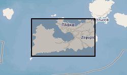
Shortwave infrared (SWIR) data of hydrothermal alteration from the island of Milos, Greece (NERC Grant NE/L002434/1)
This dataset provides an overview of hydrothermal alteration samples from the island of Milos, Greece, that were analysed using a portable infrared mineral analyser (PIMA) or AgriSpec spectrometer. During data acquisition, spectrums were input into The Spectral Geologist (TSG) to provide an instant and estimated mineral identification using the shortwave infrared (SWIR) part of the electromagnetic spectrum. The samples were acquired during field visits between 2017 - 2019 by the British Geological Survey and the GW4+ Doctorial Training Partnership (NE/L002434/1). This data was primarily used to aid sample collection for further hydrothermal alteration analyses to improve our understanding of regional and local paleo-hydrothermal activity across the island. Identification by the TSG provides an estimation only, and the raw data files in .txt, .fos and .csv formats, are supplied for each analysis in the attached zipped file. This may be useful within the metallic and industrial mineral mining sector and associated researchers. The data includes grid references (± 5 m), TSG interpretations, and field/sample observations noted during data acquisition. GW4+ Doctoral Training Partnership (NE/L002434/1) is supported by grant award GA/09F/139 – RMS E3557, and the British Geological Survey’s University Funding Initiative (BUFI S345).
Simple
- Date (Creation)
- 2021-01-29
- Citation identifier
- http://data.bgs.ac.uk/id/dataHolding/13607708
- Point of contact
-
Organisation name Individual name Electronic mail address Role University of Bristol
Valdes, Professor Paul
not available
Principal investigator British Geological Survey
Enquiries
Distributor British Geological Survey
Enquiries
Originator British Geological Survey
Enquiries
not available
Distributor British Geological Survey
Enquiries
not available
Point of contact
- Maintenance and update frequency
- notApplicable
-
GEMET - INSPIRE themes, version 1.0
-
BGS Thesaurus of Geosciences
-
-
Mining
-
Economic geology
-
Hydrothermal alteration
-
Bentonite
-
Clays
-
Mineral deposits
-
Sulphates
-
- dataCentre
- Keywords
-
-
NERC_DDC
-
- Access constraints
- Other restrictions
- Other constraints
- licenceOGL
- Use constraints
- Other restrictions
- Other constraints
-
The copyright of materials derived from the British Geological Survey's work is vested in the Natural Environment Research Council [NERC]. No part of this work may be reproduced or transmitted in any form or by any means, or stored in a retrieval system of any nature, without the prior permission of the copyright holder, via the BGS Intellectual Property Rights Manager. Use by customers of information provided by the BGS, is at the customer's own risk. In view of the disparate sources of information at BGS's disposal, including such material donated to BGS, that BGS accepts in good faith as being accurate, the Natural Environment Research Council (NERC) gives no warranty, expressed or implied, as to the quality or accuracy of the information supplied, or to the information's suitability for any use. NERC/BGS accepts no liability whatever in respect of loss, damage, injury or other occurence however caused.
- Other constraints
-
Available under the Open Government Licence subject to the following acknowledgement accompanying the reproduced NERC materials "Contains NERC materials ©NERC [year]"
- Spatial representation type
- Text, table
- Language
- English
- Topic category
-
- Geoscientific information
- Geographic identifier
-
MILOS [id=361650]
British Geological Survey Gazetteer: Geographical hierarchy from Geosaurus 1979 creation
))
- Begin date
- 2017-05-10
- End date
- 2019-09-13
- Unique resource identifier
- WGS 84 (EPSG::4326)
- Distribution format
-
Name Version Microsoft Excel (XLSX)
witheld
Comma-separated values (CSV)
witheld
Text file (TXT)
witheld
.fos
witheld
- Distributor contact
-
Organisation name Individual name Electronic mail address Role British Geological Survey
Enquiries
Distributor
- Distributor contact
-
Organisation name Individual name Electronic mail address Role British Geological Survey
Enquiries
not available
Distributor
- OnLine resource
-
Protocol Linkage Name WWW:DOWNLOAD-1.0-http--download
https://webapps.bgs.ac.uk/services/ngdc/accessions/index.html#item162145 Data
- OnLine resource
-
Protocol Linkage Name WWW:LINK-1.0-http--related
https://doi.org/10.5285/fd12ee34-dad5-4ad5-b373-fe54abe5f262 Citation Information - Digital Object Identifier (DOI)
- Hierarchy level
- Dataset
- Other
-
dataset
Conformance result
- Title
-
INSPIRE Implementing rules laying down technical arrangements for the interoperability and harmonisation of Geology
- Date (Publication)
- 2011
- Explanation
-
See the referenced specification
- Pass
- No
Conformance result
- Title
-
Commission Regulation (EU) No 1089/2010 of 23 November 2010 implementing Directive 2007/2/EC of the European Parliament and of the Council as regards interoperability of spatial data sets and services
- Date (Publication)
- 2010-12-08
- Explanation
-
See http://eur-lex.europa.eu/LexUriServ/LexUriServ.do?uri=OJ:L:2010:323:0011:0102:EN:PDF
- Pass
- No
- Statement
-
Hydrothermal alteration samples were analysed using a portable infrared mineral analyser (PIMA) or AgriSpec spectrometer. During data acquisition, spectrums were input into The Spectral Geologist (TSG) to provide an instant and estimated mineral identification using the shortwave infrared (SWIR) part of the electromagnetic spectrum. The samples were acquired during field visits between 2017 - 2019 by the British Geological Survey and the GW4+ Doctorial Training Partnership (NE/L002434/1). Background measurements were taken at the beginning, after every ten readings, and at the end of the analysis, to monitor the background response of the instruments.
Metadata
- File identifier
- ba70c6ac-5a39-2b47-e054-002128a47908 XML
- Metadata language
- English
- Hierarchy level
- Dataset
- Date stamp
- 2026-07-26
- Metadata standard name
- UK GEMINI
- Metadata standard version
-
2.3
- Metadata author
-
Organisation name Individual name Electronic mail address Role British Geological Survey
Point of contact
- Dataset URI
)))
