BGS Data Catalogue
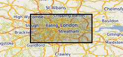
London Earth Topsoil Chemical Data
The London Earth data is part of a nationwide project to determine the distribution of chemical elements in the surface environment, namely Geochemical Baseline Survey of the Environment (G-BASE). London Earth focuses on the soil of the capital city, the limits of the survey being defined by the Greater London Authority (GLA) administrative boundary. Chemical elements have been determined by X-ray fluorescence spectrometry (XRFS) at the laboratories of the British Geological Survey (BGS) in Keyworth, Nottingham. These results are presented as a MS Excel file.
INSPIRE
Identification
- File identifier
- a3750a7d-4037-035e-e044-0003ba9b0d98 XML
- Resource type
- dataset
Online resource
- Protocol
-
HTTP
Resource identifier
- Metadata Language
- English (en)
- Spatial representation type
- textTable
Encoding
- Format
-
Excel Files
- Version
-
Current BGS Version
Projection
Classification of data and services
- Topic category
-
- Geoscientific information
Classification of data and services
Coupled resource
Coupled resource
Classification of data and services
Coupled resource
Coupled resource
Keywords
- GEMET - INSPIRE themes, version 1.0
- BGS Thesaurus of Geosciences
-
-
Chemical analysis
-
Copper
-
Soils
-
Geochemical maps
-
Lead
-
Soil sampling
-
Cadmium
-
Iron
-
Arsenic
-
Geochemical sampling
-
Selenium
-
Zinc
-
UK Location (INSPIRE)
-
Nickel
-
Soil chemistry
-
Soil surveys
-
Top soil
-
Calcium
-
Chromium
-
Soil analysis
-
Geographic coverage
))
Temporal reference
Temporal extent
Temporal extent
- Dataset Reference Date ()
- 2011
Quality and validity
- Lineage
-
Soil samples were collected as part of the G-BASE project. Samples were analysed by XRFS which gives total element concentrations in the soil samples. Several different XRFS instruments were used (wave dispersive and energy dispersive) to determine 53 chemical elements. Three elements, chlorine (Cl), indium (In) and tellurium (Te) are excluded from the released data set as the majority (>95wt%) of the results for these elements are below the lower limit of detection. Loss on ignition (LOI) (an indicator of the soil�s organic content) and pH has also been determined.
- Denominator
- 10000
Conformity
Conformity
Conformity
Conformity
Conformity
Conformity
- Explanation
-
See the referenced specification
Restrictions on access and use
- Access constraints
- Available to 3rd parties under licence
- Access constraints
-
The copyright of materials derived from the British Geological Survey's work is vested in the Natural Environment Research Council [NERC]. No part of this work may be reproduced or transmitted in any form or by any means, or stored in a retrieval system of any nature, without the prior permission of the copyright holder, via the BGS Intellectual Property Rights Manager. Use by customers of information provided by the BGS, is at the customer's own risk. In view of the disparate sources of information at BGS's disposal, including such material donated to BGS, that BGS accepts in good faith as being accurate, the Natural Environment Research Council (NERC) gives no warranty, expressed or implied, as to the quality or accuracy of the information supplied, or to the information's suitability for any use. NERC/BGS accepts no liability whatever in respect of loss, damage, injury or other occurence however caused.
- Access constraints
-
The dataset is made available to external clients under BGS Digital Data Licence terms and conditions. Revert to the IPR Section (iprdigital@bgs.ac.uk) if further advice is required with regard to permitted usage. iprdigital@bgs.ac The dataset is made available to external clients under BGS Digital Data Licence terms and conditions. Revert to the IPR Section (iprdigital@bgs.ac.uk) if further advice is required with regard to permitted usage.
Responsible organization (s)
Contact for the resource
- Organisation name
-
British Geological Survey
-
enquiries@bgs.ac enquiries@bgs.ac.uk
- Organisation name
-
British Geological Survey
-
enquiries@bgs.ac enquiries@bgs.ac.uk
- Organisation name
-
British Geological Survey
-
enquiries@bgs.ac enquiries@bgs.ac.uk
Metadata information
Contact for the metadata
- Organisation name
-
British Geological Survey
-
enquiries@bgs.ac enquiries@bgs.ac.uk
- Metadata Date
- 2024-04-18
- Metadata Language
- English (en)