 BGS Metadata Catalogue
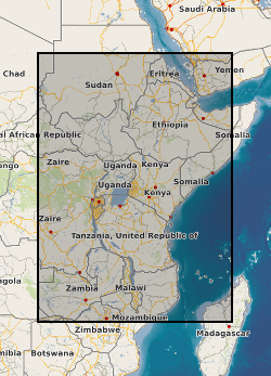
East African Rift Temperature and Heatflow model (EARTH)
A geographic information system (GIS) heat flow and temperature model of East Africa created by extracting data from open sources into a series of shapefiles and rasters containing information on geothermal sites, hot spring locations, digital elevation model, surface temperature, geothermal gradients, thermal conductivities and heat flow data, major faults, surface geology, crustal basement, electrification grid system and population density across East Africa. This data is stored in the World Geodetic System (WGS) 1984 Geographic Projection System.
Simple
- Date (Creation)
- 2020-02-14
- Citation identifier
- http://data.bgs.ac.uk/id/dataHolding/13607585
- Point of contact
-
Organisation name Individual name Electronic mail address Role British Geological Survey
Enquiries
Distributor British Geological Survey
Enquiries
Point of contact
- Maintenance and update frequency
- Unknown
-
GEMET - INSPIRE themes, version 1.0
-
BGS Thesaurus of Geosciences
-
-
Geothermal heat flow
-
Rift faults
-
Rift zone
-
Temperature
-
- dataCentre
- Keywords
-
-
NERC_DDC
-
- Access constraints
- Other restrictions
- Other constraints
- no limitations
- Other constraints
- The dataset is made freely available for access, e.g. via the Internet. Either no third party data / information is contained in the dataset or BGS has secured written permission from the owner(s) of any third party data / information contained in the dataset to make the dataset freely accessible.
- Use constraints
- Other restrictions
- Other constraints
-
The copyright of materials derived from the British Geological Survey's work is vested in the Natural Environment Research Council [NERC]. No part of this work may be reproduced or transmitted in any form or by any means, or stored in a retrieval system of any nature, without the prior permission of the copyright holder, via the BGS Intellectual Property Rights Manager. Use by customers of information provided by the BGS, is at the customer's own risk. In view of the disparate sources of information at BGS's disposal, including such material donated to BGS, that BGS accepts in good faith as being accurate, the Natural Environment Research Council (NERC) gives no warranty, expressed or implied, as to the quality or accuracy of the information supplied, or to the information's suitability for any use. NERC/BGS accepts no liability whatever in respect of loss, damage, injury or other occurence however caused.
- Other constraints
-
Available under the Open Government Licence subject to the following acknowledgement accompanying the reproduced NERC materials "Contains NERC materials ©NERC [year]"
- Spatial representation type
- Text, table
- Language
- English
- Topic category
-
- Geoscientific information
- Geographic identifier
-
BDI
ISO 3166_1 alpha-3 2009 revision
- Geographic identifier
-
BI
ISO 3166_1 alpha-2 2009 revision
- Geographic identifier
-
BURUNDI [id=658000]
British Geological Survey Gazetteer: Geographical hierarchy from Geosaurus 1979 creation
- Geographic identifier
-
EAST AFRICA [id=680000]
British Geological Survey Gazetteer: Geographical hierarchy from Geosaurus 1979 creation
- Geographic identifier
-
ER
ISO 3166_1 alpha-2 2009 revision
- Geographic identifier
-
ERI
ISO 3166_1 alpha-3 2009 revision
- Geographic identifier
-
ERITREA [id=694100]
British Geological Survey Gazetteer: Geographical hierarchy from Geosaurus 1979 creation
- Geographic identifier
-
ET
ISO 3166_1 alpha-2 2009 revision
- Geographic identifier
-
ETH
ISO 3166_1 alpha-3 2009 revision
- Geographic identifier
-
ETHIOPIA [id=692000]
British Geological Survey Gazetteer: Geographical hierarchy from Geosaurus 1979 creation
- Geographic identifier
-
JIBUTI [id=696000]
British Geological Survey Gazetteer: Geographical hierarchy from Geosaurus 1979 creation
- Geographic identifier
-
KE
ISO 3166_1 alpha-2 2009 revision
- Geographic identifier
-
KEN
ISO 3166_1 alpha-3 2009 revision
- Geographic identifier
-
KENYA [id=687000]
British Geological Survey Gazetteer: Geographical hierarchy from Geosaurus 1979 creation
- Geographic identifier
-
MALAWI [id=679000]
British Geological Survey Gazetteer: Geographical hierarchy from Geosaurus 1979 creation
- Geographic identifier
-
MOZ
ISO 3166_1 alpha-3 2009 revision
- Geographic identifier
-
MOZAMBIQUE [id=676000]
British Geological Survey Gazetteer: Geographical hierarchy from Geosaurus 1979 creation
- Geographic identifier
-
MW
ISO 3166_1 alpha-2 2009 revision
- Geographic identifier
-
MWI
ISO 3166_1 alpha-3 2009 revision
- Geographic identifier
-
MZ
ISO 3166_1 alpha-2 2009 revision
- Geographic identifier
-
RW
ISO 3166_1 alpha-2 2009 revision
- Geographic identifier
-
RWA
ISO 3166_1 alpha-3 2009 revision
- Geographic identifier
-
RWANDA [id=657000]
British Geological Survey Gazetteer: Geographical hierarchy from Geosaurus 1979 creation
- Geographic identifier
-
TANZANIA [id=685000]
British Geological Survey Gazetteer: Geographical hierarchy from Geosaurus 1979 creation
- Geographic identifier
-
UG
ISO 3166_1 alpha-2 2009 revision
- Geographic identifier
-
UGA
ISO 3166_1 alpha-3 2009 revision
- Geographic identifier
-
UGANDA [id=689000]
British Geological Survey Gazetteer: Geographical hierarchy from Geosaurus 1979 creation
- Geographic identifier
-
ZAMBIA [id=678000]
British Geological Survey Gazetteer: Geographical hierarchy from Geosaurus 1979 creation
- Geographic identifier
-
ZM
ISO 3166_1 alpha-2 2009 revision
- Geographic identifier
-
ZMB
ISO 3166_1 alpha-3 2009 revision
))
- Begin date
- 2019-04-01
- End date
- 2020-02-14
- Unique resource identifier
- WGS 84 (EPSG::4326)
- Distribution format
-
Name Version
- Distributor contact
-
Organisation name Individual name Electronic mail address Role British Geological Survey
Enquiries
Distributor
- OnLine resource
-
Protocol Linkage Name WWW:DOWNLOAD-1.0-http--download
https://webapps.bgs.ac.uk/services/ngdc/accessions/index.html#item132705 East African Rift Temperature and Heatflow model (EARTH)
- Hierarchy level
- Dataset
- Other
-
dataset
Conformance result
- Title
-
INSPIRE Implementing rules laying down technical arrangements for the interoperability and harmonisation of Geology
- Date (Publication)
- 2011
- Explanation
-
See the referenced specification
- Pass
- No
Conformance result
- Title
-
Commission Regulation (EU) No 1089/2010 of 23 November 2010 implementing Directive 2007/2/EC of the European Parliament and of the Council as regards interoperability of spatial data sets and services
- Date (Publication)
- 2010-12-08
- Explanation
-
See http://eur-lex.europa.eu/LexUriServ/LexUriServ.do?uri=OJ:L:2010:323:0011:0102:EN:PDF
- Pass
- No
- Statement
-
All data has been assimilated into a Arc GIS project.
Metadata
- File identifier
- 9ed81520-0453-65a8-e054-002128a47908 XML
- Metadata language
- English
- Hierarchy level
- Dataset
- Date stamp
- 2026-06-26
- Metadata standard name
- UK GEMINI
- Metadata standard version
-
2.3
- Metadata author
-
Organisation name Individual name Electronic mail address Role British Geological Survey
Point of contact
- Dataset URI
)))
