BGS Data Catalogue
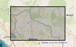
Eastern Bolivia Regional Geochemical Survey.
Between 1976 and 1982, the Overseas Directorate of the British Geological Survey, United Kingdom and the Geological Survey of Bolivia, Santa Cruz, carried out a major reconnaissance geological mapping, geochemical sampling and mineral exploration programme of that part of the Precambrian Brazilian Shield lying within eastern Bolivia. Previous geological work had been undertaken in the area, but this was the first time that a systematic and fully integrated survey had been attempted. The Project area is approximately 220,000 square kilometres and regional geochemical samples were collected from 8185 sites producing an overall sampling density of 1 sample per 27 square kilometres. Because of logistic problems it was impossible to sample certain inaccessible areas so the actual sampling density was 1 sample per 16 square kilometres for the 130,000 square kilometres effectively sampled. The geochemical samples were analysed in the Project laboratories in Santa Cruz and in the GEOBOL geochemical laboratories in La Paz. Uranium analyses were carried out by a commercial laboratory in the UK. The results of the Project are incorporated in 21 comprehensive reports in both English and Spanish. Twelve describe the geology, geochemistry and mineral potential of the individual 1:250,000 map areas and the remainder are devoted to the geology and mineral potential of areas of special geological or economic interest. The stream sediments were determined for: Ag, Co, Cu, Fe, Mn, Ni, Pb, Zn, As, U, B, Ba, Be, Cr, La, Li, Mo, Nb, Sn, Sr, Y, and Zr. These results are presented in an atlas as 22 single element 1:1 million scale, classed proportional symbol, point source data maps in which the symbols are overprinted on a simplified geological base map in order to facilitate rapid data interpretation. A 1:4 million scale moving average map based on a 4 x 4 km cell size and a 10 km search radius, printed alongside the symbol map, identifies the major regional variations. Raw data is available from the Geological Survey of Bolivia, Santa Cruz along with copies of the reports.
INSPIRE
Identification
- File identifier
- 9df8df52-d770-37a8-e044-0003ba9b0d98 XML
- Resource type
- dataset
Online resource
Resource identifier
- Metadata Language
- English (en)
- Spatial representation type
- grid
Encoding
- Format
-
ATLAS - Available as a Atlas.
- Format
-
Data in various formats, MS Excel, MS Word and image files available on a CD-ROM
Projection
Classification of data and services
- Topic category
-
- Geoscientific information
Classification of data and services
Coupled resource
Coupled resource
Classification of data and services
Coupled resource
Coupled resource
Keywords
- GEMET - INSPIRE themes, version 1.0
- BGS Thesaurus of Geosciences
-
-
Geochemistry
-
Geological maps
-
Geology
-
Exploration
-
Uranium
-
Geochemical mapping
-
Geochemical exploration
-
Minerals
-
data.gov.uk (non-INSPIRE)
-
Geochemical sampling
-
Mineral exploration
-
Geochemical maps
-
Geographic coverage
))
Temporal reference
Temporal extent
Temporal extent
- Dataset Reference Date ()
- 1976
Quality and validity
- Lineage
-
CD-Rom database derived from digital files produced for atlas production.
- Denominator
- 1000000
Conformity
Conformity
Conformity
Conformity
Conformity
Conformity
- Explanation
-
See the referenced specification
Restrictions on access and use
- Access constraints
- Subject to a licence fee. Subject to usual BGS terms and conditions.
- Access constraints
-
The copyright of materials derived from the British Geological Survey's work is vested in the Natural Environment Research Council [NERC]. No part of this work may be reproduced or transmitted in any form or by any means, or stored in a retrieval system of any nature, without the prior permission of the copyright holder, via the BGS Intellectual Property Rights Manager. Use by customers of information provided by the BGS, is at the customer's own risk. In view of the disparate sources of information at BGS's disposal, including such material donated to BGS, that BGS accepts in good faith as being accurate, the Natural Environment Research Council (NERC) gives no warranty, expressed or implied, as to the quality or accuracy of the information supplied, or to the information's suitability for any use. NERC/BGS accepts no liability whatever in respect of loss, damage, injury or other occurence however caused.
- Access constraints
-
Either: (i) the dataset is made freely available, e.g. via the Internet, for a restricted category of use (e.g. educational use only); or (ii) the dataset has not been formally approved by BGS for access and use by external clients under licence, but its use may be permitted under alternative formal arrangements; or (iii) the dataset contains 3rd party data or information obtained by BGS under terms and conditions that must be consulted in order to determine the permitted usage of the dataset. Refer to the BGS staff member responsible for the creation of the dataset if further advice is required. He / she should be familiar with the composition of the dataset, particularly with regard to 3rd party IPR contained in it, and any resultant use restrictions. This staff member should revert to the IPR Section (ipr@bgs.ac.uk) for advice, should the position not be clear. ipr@bgs.ac Either: (i) the dataset is made freely available, e.g. via the Internet, for a restricted category of use (e.g. educational use only); or (ii) the dataset has not been formally approved by BGS for access and use by external clients under licence, but its use may be permitted under alternative formal arrangements; or (iii) the dataset contains 3rd party data or information obtained by BGS under terms and conditions that must be consulted in order to determine the permitted usage of the dataset. Refer to the BGS staff member responsible for the creation of the dataset if further advice is required. He / she should be familiar with the composition of the dataset, particularly with regard to 3rd party IPR contained in it, and any resultant use restrictions. This staff member should revert to the IPR Section (ipr@bgs.ac.uk) for advice, should the position not be clear.
Responsible organization (s)
Contact for the resource
- Organisation name
-
British Geological Survey
-
enquiries@bgs.ac enquiries@bgs.ac.uk
- Organisation name
-
British Geological Survey
-
enquiries@bgs.ac enquiries@bgs.ac.uk
- Organisation name
-
British Geological Survey
-
enquiries@bgs.ac enquiries@bgs.ac.uk
- Organisation name
-
British Geological Survey
-
enquiries@bgs.ac enquiries@bgs.ac.uk
Metadata information
Contact for the metadata
- Organisation name
-
British Geological Survey
-
enquiries@bgs.ac enquiries@bgs.ac.uk
- Metadata Date
- 2024-04-24
- Metadata Language
- English (en)