BGS Data Catalogue
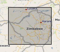
Zimbabwe Regional Geochemical Survey.
During the period 1982-86 a team of geologists from the British Geological Survey carried out a programme of regional geological mapping and geochemical exploration in collaboration with the Zimbabwe Geological Survey under a Technical Co-operation agreement supported by the UK Department for International Development (DFID) (formerly Overseas Development Agency). Three regions of Zimbabwe were mapped (Harare, Rushinga & Nyampanda, and Makaha) and the results of the stream sediment geochemical surveys were presented as three reports. Over 17,000 stream sediments were collected and analysed for Cu, Pb, Zn, Co, Ni, Mn, Li, As, Ba, Sn, Ta, and W. Raw data can be obtained from the Geological Survey of Zimbabwe, PO Box CY210,Causeway, Harare, Zimbabwe.
INSPIRE
Identification
- File identifier
- 9df8df51-63db-37a8-e044-0003ba9b0d98 XML
- Resource type
- dataset
Online resource
Resource identifier
- Metadata Language
- English (en)
- Spatial representation type
- grid
Encoding
- Format
-
Data in various formats, MS Excel, MS Word and image files available on a CD-ROM
- Version
-
1.1 Feb.1999
Projection
Classification of data and services
- Topic category
-
- Geoscientific information
Classification of data and services
Coupled resource
Coupled resource
Classification of data and services
Coupled resource
Coupled resource
Keywords
- GEMET - INSPIRE themes, version 1.0
- BGS Thesaurus of Geosciences
-
-
Geochemical exploration
-
Geology
-
data.gov.uk (non-INSPIRE)
-
Exploration
-
Geochemical maps
-
Geochemistry
-
Regional geology
-
Geographic coverage
))
Temporal reference
Temporal extent
Temporal extent
- Dataset Reference Date ()
- 1982
Quality and validity
- Lineage
-
This work pre-dated the desktop PC era and the analytical data was stored on a Cifer 1880 microcomputer and PDP11 magnetic tapes. These data have recently been transferred to PC format and stored as a CD-ROM database. Some of the XRF data was lost.
- Denominator
- 10000
Conformity
Conformity
Conformity
Conformity
Conformity
Conformity
- Explanation
-
See the referenced specification
Restrictions on access and use
- Access constraints
- Subject to a licence fee. Subject to usual BGS terms and conditions.
- Access constraints
-
The copyright of materials derived from the British Geological Survey's work is vested in the Natural Environment Research Council [NERC]. No part of this work may be reproduced or transmitted in any form or by any means, or stored in a retrieval system of any nature, without the prior permission of the copyright holder, via the BGS Intellectual Property Rights Manager. Use by customers of information provided by the BGS, is at the customer's own risk. In view of the disparate sources of information at BGS's disposal, including such material donated to BGS, that BGS accepts in good faith as being accurate, the Natural Environment Research Council (NERC) gives no warranty, expressed or implied, as to the quality or accuracy of the information supplied, or to the information's suitability for any use. NERC/BGS accepts no liability whatever in respect of loss, damage, injury or other occurence however caused.
- Access constraints
-
Either: (i) the dataset is made freely available, e.g. via the Internet, for a restricted category of use (e.g. educational use only); or (ii) the dataset has not been formally approved by BGS for access and use by external clients under licence, but its use may be permitted under alternative formal arrangements; or (iii) the dataset contains 3rd party data or information obtained by BGS under terms and conditions that must be consulted in order to determine the permitted usage of the dataset. Refer to the BGS staff member responsible for the creation of the dataset if further advice is required. He / she should be familiar with the composition of the dataset, particularly with regard to 3rd party IPR contained in it, and any resultant use restrictions. This staff member should revert to the IPR Section (ipr@bgs.ac.uk) for advice, should the position not be clear. ipr@bgs.ac Either: (i) the dataset is made freely available, e.g. via the Internet, for a restricted category of use (e.g. educational use only); or (ii) the dataset has not been formally approved by BGS for access and use by external clients under licence, but its use may be permitted under alternative formal arrangements; or (iii) the dataset contains 3rd party data or information obtained by BGS under terms and conditions that must be consulted in order to determine the permitted usage of the dataset. Refer to the BGS staff member responsible for the creation of the dataset if further advice is required. He / she should be familiar with the composition of the dataset, particularly with regard to 3rd party IPR contained in it, and any resultant use restrictions. This staff member should revert to the IPR Section (ipr@bgs.ac.uk) for advice, should the position not be clear.
Responsible organization (s)
Contact for the resource
- Organisation name
-
British Geological Survey
-
enquiries@bgs.ac enquiries@bgs.ac.uk
- Organisation name
-
British Geological Survey
-
enquiries@bgs.ac enquiries@bgs.ac.uk
- Organisation name
-
British Geological Survey
-
enquiries@bgs.ac enquiries@bgs.ac.uk
- Organisation name
-
British Geological Survey
-
enquiries@bgs.ac enquiries@bgs.ac.uk
Metadata information
Contact for the metadata
- Organisation name
-
British Geological Survey
-
enquiries@bgs.ac enquiries@bgs.ac.uk
- Metadata Date
- 2024-04-18
- Metadata Language
- English (en)