BGS Data Catalogue
Metal Speciation And Bioavailability For Risk Assessment And Remediation.
The full title of this project is" Studies into metal speciation and bioavailability to assist risk assessment and remediation of brownfield sites in urban areas" and is funded by NERC under the URGENT thematic programme form 1998-2001. The project is being undertaken by a consortium of workers from the Imperial College, University of Nottingham, and the British Geological Survey. Innovative collaborative and multi-disciplinary research will be applied to the interpretation of urban geochemical maps and associated meta-datasets to assist decision making by local authorities in the redevelopment of brownfield sites. Source apportionment, speciation and bioavailability of potentially toxic heavy metals will be studied at representative conurbations in the UK Midlands region. Scanning electron microscopy, chemical extractions and soil solution and vegetable analysis, will be integrated with high precision isotopic analyses of Pb and other potential toxic metals in this study. The results will be available as maps in GIS format to provide a generic decision support system for quantitative health risk assessment.
INSPIRE
Identification
- File identifier
- 9df8df51-6358-37a8-e044-0003ba9b0d98 XML
- Resource type
- dataset
Online resource
Resource identifier
- Metadata Language
- English (en)
Encoding
- Format
-
MAPS/GIS
Projection
Classification of data and services
- Topic category
-
- Geoscientific information
Classification of data and services
Coupled resource
Coupled resource
Classification of data and services
Coupled resource
Coupled resource
Keywords
- GEMET - INSPIRE themes, version 1.0
- BGS Thesaurus of Geosciences
-
-
UK Location (INSPIRE)
-
Minerals
-
Geochemistry
-
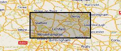
Geographic coverage
))
Temporal reference
Temporal extent
Temporal extent
- Dataset Reference Date ()
- 1998
Quality and validity
- Lineage
-
This dataset is generated entirely from the URGENT project "Studies into metal speciation and bioavailability to assist risk assessment and remediation of brownfield sites in urban areas", which was begun in October 1998 and will run for 2.5 years.
- Denominator
- 10000
Conformity
Conformity
Conformity
Conformity
Conformity
Conformity
- Explanation
-
See the referenced specification
Restrictions on access and use
- Access constraints
-
The copyright of materials derived from the British Geological Survey's work is vested in the Natural Environment Research Council [NERC]. No part of this work may be reproduced or transmitted in any form or by any means, or stored in a retrieval system of any nature, without the prior permission of the copyright holder, via the BGS Intellectual Property Rights Manager. Use by customers of information provided by the BGS, is at the customer's own risk. In view of the disparate sources of information at BGS's disposal, including such material donated to BGS, that BGS accepts in good faith as being accurate, the Natural Environment Research Council (NERC) gives no warranty, expressed or implied, as to the quality or accuracy of the information supplied, or to the information's suitability for any use. NERC/BGS accepts no liability whatever in respect of loss, damage, injury or other occurence however caused.
- Access constraints
-
Either: (i) the dataset is made freely available, e.g. via the Internet, for a restricted category of use (e.g. educational use only); or (ii) the dataset has not been formally approved by BGS for access and use by external clients under licence, but its use may be permitted under alternative formal arrangements; or (iii) the dataset contains 3rd party data or information obtained by BGS under terms and conditions that must be consulted in order to determine the permitted usage of the dataset. Refer to the BGS staff member responsible for the creation of the dataset if further advice is required. He / she should be familiar with the composition of the dataset, particularly with regard to 3rd party IPR contained in it, and any resultant use restrictions. This staff member should revert to the IPR Section (ipr@bgs.ac.uk) for advice, should the position not be clear. ipr@bgs.ac Either: (i) the dataset is made freely available, e.g. via the Internet, for a restricted category of use (e.g. educational use only); or (ii) the dataset has not been formally approved by BGS for access and use by external clients under licence, but its use may be permitted under alternative formal arrangements; or (iii) the dataset contains 3rd party data or information obtained by BGS under terms and conditions that must be consulted in order to determine the permitted usage of the dataset. Refer to the BGS staff member responsible for the creation of the dataset if further advice is required. He / she should be familiar with the composition of the dataset, particularly with regard to 3rd party IPR contained in it, and any resultant use restrictions. This staff member should revert to the IPR Section (ipr@bgs.ac.uk) for advice, should the position not be clear.
Responsible organization (s)
Contact for the resource
- Organisation name
-
British Geological Survey
-
enquiries@bgs.ac enquiries@bgs.ac.uk
- Organisation name
-
British Geological Survey
-
enquiries@bgs.ac enquiries@bgs.ac.uk
- Organisation name
-
British Geological Survey
-
enquiries@bgs.ac enquiries@bgs.ac.uk
Metadata information
Contact for the metadata
- Organisation name
-
British Geological Survey
-
enquiries@bgs.ac enquiries@bgs.ac.uk
- Metadata Date
- 2024-04-25
- Metadata Language
- English (en)