BGS Data Catalogue
Groundwater level logger data for 7 wells , Kwale County, Kenya (NERC grant NE/M008894/1)
The data sets contain the daily record of meters of groundwater columns for 7 Heron logger transducers installed in different boreholes and wells in the study area. Missing data denoted -9999. The Barlog data for atmospheric pressure (Atmospheric Pressure data measured by Heron Barologger for the period of April 2014 to November 2018 at Munje Jabalini.) is also included. "Uncomp.HT.WTR. Above Transducer" corresponds to the actual pressure the dipperLog is measuring. "Barologger Data" corresponds to the Barlog data for atmospheric pressure at Munje Jabalini "Comp.Depth.WTR Below the Datum" is the "Depth below datum" entered in the logger setup less "Comp.HT.WTR. Above Transducer". The data was collected by Albert Folch and Nuria Ferrer (UPC), Mike Lane and Calvince Wara (Rural Focus Ltd). The PI on the Gro for GooD project was Prof. Rob Hope, University of Oxford.
INSPIRE
Identification
- File identifier
- 974c9081-fc8b-4d34-e054-002128a47908 XML
- Hierarchy level
- Dataset
Online resource
Resource identifier
- Metadata language
- English
Encoding
- Format
-
MS Excel
Projection
Classification of data and services
- Topic category
-
- Geoscientific information
Keywords
-
GEMET - INSPIRE themes, version 1.0
-
BGS Thesaurus of Geosciences
-
-
Groundwater
-
Monitoring
-
NGDC Deposited Data
-
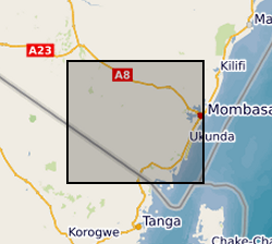
Geographic coverage
))
Temporal reference
Temporal extent
- Begin
- 2016-04-01
- End
- 2018-11-16
Temporal extent
- Date (Creation)
- 2019-10-31
Quality and validity
- Lineage
-
Seven wells/boreholes were carefully selected in order to install a logger sensor (Heron logger transducer) to provide a continuous measure of groundwater level. The sites were selected according to the location in the study area, the security of the waterpoint, the geology, the aquifer unit (in this case all the logger are installed in the shallow aquifer< than 50-meter depth). First, the loggers were programmed to take a measurement every 15 minutes and then re-programmed to take a measurement every hour. Before installing the sensor, the groundwater level was measured with a dipper and the sensor was then installed below the groundwater level depth in order to avoid that the sensor remained submerged. It was necessary to download data before the logger memory was full, and then re-program again to continue measuring.
Conformity
Conformity
Conformity
Restrictions on access and use
- Access constraints
- no limitations
- Access constraints
- The dataset is made freely available for access, e.g. via the Internet. Either no third party data / information is contained in the dataset or BGS has secured written permission from the owner(s) of any third party data / information contained in the dataset to make the dataset freely accessible.
- Access constraints
-
The copyright of materials derived from the British Geological Survey's work is vested in the Natural Environment Research Council [NERC]. No part of this work may be reproduced or transmitted in any form or by any means, or stored in a retrieval system of any nature, without the prior permission of the copyright holder, via the BGS Intellectual Property Rights Manager. Use by customers of information provided by the BGS, is at the customer's own risk. In view of the disparate sources of information at BGS's disposal, including such material donated to BGS, that BGS accepts in good faith as being accurate, the Natural Environment Research Council (NERC) gives no warranty, expressed or implied, as to the quality or accuracy of the information supplied, or to the information's suitability for any use. NERC/BGS accepts no liability whatever in respect of loss, damage, injury or other occurence however caused.
- Access constraints
-
Available under the Open Government Licence subject to the following acknowledgement accompanying the reproduced NERC materials "Contains NERC materials ©NERC [year]"
Responsible organization (s)
Contact for the resource
- Organisation name
-
University of Oxford
-
not available
- Organisation name
-
University of Oxford
-
not available
- Organisation name
-
Rural Focus Ltd
-
not available
- Organisation name
-
Universitat Politècnica de Catalunya
-
not available
- Organisation name
-
Universitat Politècnica de Catalunya
-
not available
- Organisation name
-
University of Oxford
-
not available
- Organisation name
-
University of Oxford
-
not available
- Organisation name
-
Rural Focus Ltd
-
not available
Metadata information
Contact for the metadata
- Organisation name
-
British Geological Survey
- Date stamp
- 2024-04-30
- Metadata language
- English