 BGS Metadata Catalogue
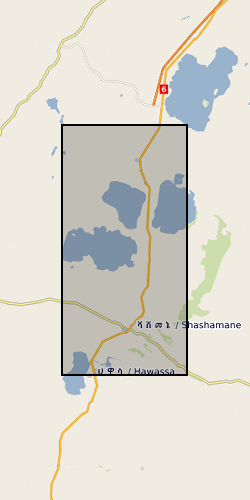
GPS Time Series For Corbetti and Aluto Volcano, Main Ethiopian Rift, Ethiopia (NERC grant NE/L013932/1)
This data set contains daily position solutions for GPS stations deployed on Corbetti and Aluto volcano, Ethiopia. The results for Aluto were originally published in "Seasonal patterns of seismicity and deformation at the Alutu geothermal reservoir, Ethiopia, induced by hydrological loading", Birhanu et. al. (2018). Corbetti results were partially published in "Sustained Uplift at a Continental Rift Caldera", Lloyd et al. (2018).
Simple
- Date (Creation)
- 2019-03-11
- Citation identifier
- http://data.bgs.ac.uk/id/dataHolding/13607453
- Point of contact
-
Organisation name Individual name Electronic mail address Role University of Edinburgh
Whaler, Kathy
Principal investigator University of Bristol
Ophelia George
not available
Point of contact
- Maintenance and update frequency
- notApplicable
-
GEMET - INSPIRE themes, version 1.0
-
BGS Thesaurus of Geosciences
-
-
Geodesy
-
Rift zone
-
GPS
-
Rift valleys
-
Ground deformation
-
- dataCentre
- Keywords
-
-
NERC_DDC
-
- Access constraints
- Other restrictions
- Other constraints
- no limitations
- Other constraints
- The dataset is made freely available for access, e.g. via the Internet. Either no third party data / information is contained in the dataset or BGS has secured written permission from the owner(s) of any third party data / information contained in the dataset to make the dataset freely accessible.
- Use constraints
- Other restrictions
- Other constraints
-
The copyright of materials derived from the British Geological Survey's work is vested in the Natural Environment Research Council [NERC]. No part of this work may be reproduced or transmitted in any form or by any means, or stored in a retrieval system of any nature, without the prior permission of the copyright holder, via the BGS Intellectual Property Rights Manager. Use by customers of information provided by the BGS, is at the customer's own risk. In view of the disparate sources of information at BGS's disposal, including such material donated to BGS, that BGS accepts in good faith as being accurate, the Natural Environment Research Council (NERC) gives no warranty, expressed or implied, as to the quality or accuracy of the information supplied, or to the information's suitability for any use. NERC/BGS accepts no liability whatever in respect of loss, damage, injury or other occurence however caused.
- Other constraints
-
Available under the Open Government Licence subject to the following acknowledgement accompanying the reproduced NERC materials "Contains NERC materials ©NERC [year]"
- Language
- English
- Topic category
-
- Geoscientific information
- Geographic identifier
-
Main Ethiopian Rift [id=985019]
British Geological Survey Gazetteer: Geographical hierarchy from Geosaurus 1979 creation
))
- Begin date
- 2013-03-22
- End date
- 2016-12-31
- Supplemental Information
-
Max Longitude: 38.79999 Min Longitude: 38.39364 Max Latitude: 7.86692 Min Latitude: 7.05149
- Unique resource identifier
- WGS 84 (EPSG::4326)
- Distribution format
-
Name Version
- OnLine resource
-
Protocol Linkage Name WWW:DOWNLOAD-1.0-http--download
https://webapps.bgs.ac.uk/services/ngdc/accessions/index.html#item126475 Data
- Hierarchy level
- Dataset
- Other
-
dataset
Conformance result
- Title
-
INSPIRE Implementing rules laying down technical arrangements for the interoperability and harmonisation of Geology
- Date (Publication)
- 2011
- Explanation
-
See the referenced specification
- Pass
- No
Conformance result
- Title
-
Commission Regulation (EU) No 1089/2010 of 23 November 2010 implementing Directive 2007/2/EC of the European Parliament and of the Council as regards interoperability of spatial data sets and services
- Date (Publication)
- 2010-12-08
- Explanation
-
See http://eur-lex.europa.eu/LexUriServ/LexUriServ.do?uri=OJ:L:2010:323:0011:0102:EN:PDF
- Pass
- No
- Statement
-
The raw GPS data were collected using Leica receivers and antennas that were continuously recording data between 2013 and 2017. They were then converted into rinex files and solutions derived with the software suite GAMIT/GLOBK using station HAWA as the reference station. Further details are provided in the ReadMe file associated with this upload.
Metadata
- File identifier
- 863e48ff-7857-47da-e054-002128a47908 XML
- Metadata language
- English
- Hierarchy level
- Dataset
- Date stamp
- 2026-07-11
- Metadata standard name
- UK GEMINI
- Metadata standard version
-
2.3
- Metadata author
-
Organisation name Individual name Electronic mail address Role British Geological Survey
Point of contact
- Dataset URI
)))
