 BGS Metadata Catalogue
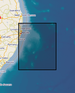
Virtual Site Survey of Pernambuco Plateau, Brazil in support of IODP 864: Origin, Evolution and Palaeoenvironment of the Equatorial Atlantic Gateway (NERC grant NE/M021238/1)
The dataset consists of: (1) Listing of full site survey package of geophysical data held in the IODP Data Bank in support of proposal 864. Details of how to obtain existing freely available or commercial proprietary data are included. (2) Final version of Full Science Proposal 864, which contains: description and illustrations of the regional stratigraphy of Pernambuco Plateau, as interpreted by the Virtual Site Survey project; site summary sheets for all proposed drill sites based on the Virtual Site Survey. (3) A complete list of all deliverables associated with this project is provided in the Data Archiving Report.
Simple
- Date (Creation)
- 2018-08-15
- Citation identifier
- http://data.bgs.ac.uk/id/dataHolding/13607369
- Point of contact
-
Organisation name Individual name Electronic mail address Role University of Birmingham
Dr Stephen M Jones
not available
Originator University of Birmingham
Dr Stephen M Jones
not available
Principal investigator British Geological Survey
Enquiries
not available
Distributor British Geological Survey
Enquiries
not available
Point of contact
- Maintenance and update frequency
- notApplicable
-
GEMET - INSPIRE themes, version 1.0
-
BGS Thesaurus of Geosciences
-
-
Marine surveys
-
Seismic reflection surveys
-
- dataCentre
- Keywords
-
-
NERC_DDC
-
- Access constraints
- Other restrictions
- Other constraints
- no limitations
- Other constraints
- The dataset is made freely available for access, e.g. via the Internet. Either no third party data / information is contained in the dataset or BGS has secured written permission from the owner(s) of any third party data / information contained in the dataset to make the dataset freely accessible.
- Use constraints
- Other restrictions
- Other constraints
-
The copyright of materials derived from the British Geological Survey's work is vested in the Natural Environment Research Council [NERC]. No part of this work may be reproduced or transmitted in any form or by any means, or stored in a retrieval system of any nature, without the prior permission of the copyright holder, via the BGS Intellectual Property Rights Manager. Use by customers of information provided by the BGS, is at the customer's own risk. In view of the disparate sources of information at BGS's disposal, including such material donated to BGS, that BGS accepts in good faith as being accurate, the Natural Environment Research Council (NERC) gives no warranty, expressed or implied, as to the quality or accuracy of the information supplied, or to the information's suitability for any use. NERC/BGS accepts no liability whatever in respect of loss, damage, injury or other occurence however caused.
- Other constraints
-
Available under the Open Government Licence subject to the following acknowledgement accompanying the reproduced NERC materials "Contains NERC materials ©NERC [year]"
- Language
- English
- Topic category
-
- Geoscientific information
- Geographic identifier
-
ATLANTIC OCEAN [id=2002254]
British Geological Survey Gazetteer: Gazetteer of sea areas 2010 revision
))
- Begin date
- 2015-09-01
- End date
- 2018-02-28
Reference System Information
- Distribution format
-
Name Version Image (PNG)
PDF
witheld
- Distributor contact
-
Organisation name Individual name Electronic mail address Role British Geological Survey
Enquiries
not available
Distributor
- OnLine resource
-
Protocol Linkage Name WWW:DOWNLOAD-1.0-http--download
https://webapps.bgs.ac.uk/services/ngdc/accessions/index.html#item113409 Data
- Hierarchy level
- Dataset
- Other
-
dataset
Conformance result
- Title
-
INSPIRE Implementing rules laying down technical arrangements for the interoperability and harmonisation of Geology
- Date (Publication)
- 2011
- Explanation
-
See the referenced specification
- Pass
- No
Conformance result
- Title
-
Commission Regulation (EU) No 1089/2010 of 23 November 2010 implementing Directive 2007/2/EC of the European Parliament and of the Council as regards interoperability of spatial data sets and services
- Date (Publication)
- 2010-12-08
- Explanation
-
See http://eur-lex.europa.eu/LexUriServ/LexUriServ.do?uri=OJ:L:2010:323:0011:0102:EN:PDF
- Pass
- No
- Statement
-
We compiled and interpreted geophysical drill site characterization data as required to support any International Ocean Discovery Program (IODP) drilling proposal. This was a "Virtual Site Survey", meaning no new data was collected, and instead we compiled and interpreted existing freely available data, together with proprietary commercial data released specifically for this project by the owners under appropriate non-disclosure agreements.
Metadata
- File identifier
- 741630af-f7eb-137b-e054-002128a47908 XML
- Metadata language
- English
- Hierarchy level
- Dataset
- Date stamp
- 2026-07-11
- Metadata standard name
- UK GEMINI
- Metadata standard version
-
2.3
- Metadata author
-
Organisation name Individual name Electronic mail address Role British Geological Survey
Point of contact
- Dataset URI
)))
