BGS Data Catalogue
Gro for GooD Soil Data Kwale County, Kenya (NERC grant NE/M008894/1)
The data set contains Soil Data used in the Gro for GooD Project in Kwale, Kenya based on KENSOTER database and soil survey in study area. The KENSOTER dataset, specific for Kenya, was compiled by the Kenya Soil Survey (KSS) and ISRIC and released in 2006 where ISRIC plays a lead role in methodology development and programme implementation ( http://www.isric.org/projects/soil-and-terrain-soter-database-programme). The dataset includes over 600 soil components, including synthetic profiles, which have been derived from soil survey reports and expert knowledge. The second version of the dataset which has been made available includes additional soil profile database and is also used for the assessment of soil carbon stocks. The gaps in the measured soil profile data have been filled using a step-wise procedure which includes three main stages: (1) collate additional measured soil analytical data where available; (2) fill gaps using expert knowledge and common sense; (3) fill the remaining gaps using a scheme of taxotransfer rules. Parameter estimates are presented by soil unit for fixed depth intervals of 0.2 m to 1 m depth for: organic carbon, total nitrogen, pH(H2O), CECsoil, CECclay, base saturation, effective CEC, aluminium saturation, CaCO3 content, gypsum content, exchangeable sodium percentage (ESP), electrical conductivity of saturated paste (ECe), bulk density, content of sand, silt and clay, content of coarse fragments, and available water capacity. The data have recently been used for the Green Water Credit (GWC) programme in the Upper Tana River Valley. This dataset was prepared for the Gro for GooD project by Mike Thomas, Rural Focus Ltd., Kenya; John Gathenya, JKUAT, Kenya. Gro for GooD: Groundwater Risk Management for Growth and Development
INSPIRE
Identification
- File identifier
- 5f9aa13b-0f0e-3af5-e054-002128a47908 XML
- Resource type
- dataset
Online resource
Resource identifier
- Metadata Language
- English (en)
- Spatial representation type
- vector
Encoding
- Format
-
.xml
- Format
-
MS Excel
- Format
-
database files (.adf)
- Format
-
text files (.txt)
Projection
Classification of data and services
- Topic category
-
- Geoscientific information
Classification of data and services
Coupled resource
Coupled resource
Classification of data and services
Coupled resource
Coupled resource
Keywords
- GEMET - INSPIRE themes, version 1.0
- BGS Thesaurus of Geosciences
-
-
NGDC Deposited Data
-
Soils
-
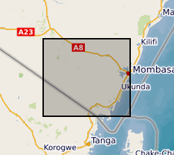
Geographic coverage
))
Temporal reference
Temporal extent
Temporal extent
- Dataset Reference Date ()
- 2017-11-17
Quality and validity
- Lineage
-
The harmonized data set was derived from Soil and Terrain Database for Kenya (KENSOTER V2), at scale 1:1M, compiled by the Kenya Soil Survey and ISRIC. The parameter estimates are presented by soil unit for fixed depth intervals of 0.2 m to 1 m depth for 20 parameter attributes which have been identified as being useful for agro-ecological zoning, land evaluation, crop growth simulation, modelling of soil carbon stocks and change, and analyses of global environmental change. The current parameters values were are best estimates based on the current selection of soil profiles and data clustering procedure. Results are presented as summary files and can be linked to SOTER map for Kenya through the unique SOTER-unit code. Soil field survey was undertaken within study area in 2016 and results compared with the SOTER parameter estimates as satisfactory to build confidence on the data sets.
Conformity
Conformity
Conformity
Conformity
Conformity
Conformity
- Explanation
-
See the referenced specification
Restrictions on access and use
- Access constraints
- no limitations
- Access constraints
- The dataset is made freely available for access, e.g. via the Internet. Either no third party data / information is contained in the dataset or BGS has secured written permission from the owner(s) of any third party data / information contained in the dataset to make the dataset freely accessible.
- Access constraints
-
The copyright of materials derived from the British Geological Survey's work is vested in the Natural Environment Research Council [NERC]. No part of this work may be reproduced or transmitted in any form or by any means, or stored in a retrieval system of any nature, without the prior permission of the copyright holder, via the BGS Intellectual Property Rights Manager. Use by customers of information provided by the BGS, is at the customer's own risk. In view of the disparate sources of information at BGS's disposal, including such material donated to BGS, that BGS accepts in good faith as being accurate, the Natural Environment Research Council (NERC) gives no warranty, expressed or implied, as to the quality or accuracy of the information supplied, or to the information's suitability for any use. NERC/BGS accepts no liability whatever in respect of loss, damage, injury or other occurence however caused.
- Access constraints
-
Available under the Open Government Licence subject to the following acknowledgement accompanying the reproduced NERC materials "Contains NERC materials ©NERC [year]"
Responsible organization (s)
Contact for the resource
- Organisation name
-
University of Oxford
-
not available
- Organisation name
-
University of Oxford
-
not available
- Organisation name
-
Rural Focus Ltd
-
not available
- Organisation name
-
Jomo Kenyatta University of Agriculture and Technology
-
not available
Metadata information
Contact for the metadata
- Organisation name
-
British Geological Survey
-
enquiries@bgs.ac enquiries@bgs.ac.uk
- Metadata Date
- 2024-04-18
- Metadata Language
- English (en)