 BGS Metadata Catalogue
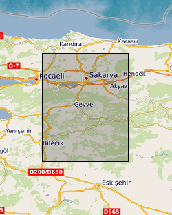
Dense Array for Northern Anatolia (DANA) (NERC grant NE/I028017/1)
A seismic dataset of 70 temporary and 3 permanent seismic stations deployed from 05/2012 to 10/2013 in northern Turkey. Three-component seismic data were collected at each location. Stations were deployed across the North Anatolian Fracture Zone (NAFZ) in the region of the 1999 Izmit and Duzce earthquakes. The network covered a footprint of ~35 by 70 km with a nominal station spacing of 7 km. Continuous seismic data were collected to study the crustal structure of the NAFZ to better understand the structure and dynamics of the NAFZ and it seismic hazard for the region. Funding for the project was provided through NERC Standard grant NE/I028017/1 and 63 stations were provided by the GEF. Additional stations were provided by the Kandilli Observatory and Earthquake Research Institute. Seismic stations were a mixture of Guralp CMG-6TD and CMG-3T. Further information can be found in GEF report for loan 947 - http://gef.nerc.ac.uk/documents/report/947. Link to data: http://ds.iris.edu/gmap/YH?timewindow=2012/5/01-2013/10/01
Simple
- Date (Creation)
- 2017-11-15
- Citation identifier
- http://data.bgs.ac.uk/id/dataHolding/13607228
- Point of contact
-
Organisation name Individual name Electronic mail address Role University of Leeds
Dr Sebastian Rost
not available
Point of contact
- Maintenance and update frequency
- notApplicable
-
GEMET - INSPIRE themes, version 1.0
-
BGS Thesaurus of Geosciences
-
-
Earthquakes
-
Tectonics
-
Seismic data
-
- dataCentre
- Keywords
-
-
NERC_DDC
-
- Access constraints
- Other restrictions
- Other constraints
- no limitations
- Other constraints
- The dataset is made freely available for access, e.g. via the Internet. Either no third party data / information is contained in the dataset or BGS has secured written permission from the owner(s) of any third party data / information contained in the dataset to make the dataset freely accessible.
- Use constraints
- Other restrictions
- Other constraints
-
The copyright of materials derived from the British Geological Survey's work is vested in the Natural Environment Research Council [NERC]. No part of this work may be reproduced or transmitted in any form or by any means, or stored in a retrieval system of any nature, without the prior permission of the copyright holder, via the BGS Intellectual Property Rights Manager. Use by customers of information provided by the BGS, is at the customer's own risk. In view of the disparate sources of information at BGS's disposal, including such material donated to BGS, that BGS accepts in good faith as being accurate, the Natural Environment Research Council (NERC) gives no warranty, expressed or implied, as to the quality or accuracy of the information supplied, or to the information's suitability for any use. NERC/BGS accepts no liability whatever in respect of loss, damage, injury or other occurence however caused.
- Other constraints
-
Available under the Open Government Licence subject to the following acknowledgement accompanying the reproduced NERC materials "Contains NERC materials ©NERC [year]"
- Language
- English
- Topic category
-
- Geoscientific information
))
- Begin date
- 2012-05-01
- End date
- 2013-09-30
Reference System Information
- Distribution format
-
Name Version
- OnLine resource
-
Protocol Linkage Name WWW:LINK-1.0-http--link
https://web.archive.org/web/20230928221355/http://gef.nerc.ac.uk/documents/report/947
- OnLine resource
-
Protocol Linkage Name http://ds.iris.edu/gmap/YH?timewindow=2012/5/01-2013/10/01
- OnLine resource
-
Protocol Linkage Name WWW:DOWNLOAD-1.0-http--download
https://webapps.bgs.ac.uk/services/ngdc/accessions/index.html#item104249 Data
- Hierarchy level
- Dataset
- Other
-
dataset
Conformance result
- Title
-
INSPIRE Implementing rules laying down technical arrangements for the interoperability and harmonisation of Geology
- Date (Publication)
- 2011
- Explanation
-
See the referenced specification
- Pass
- No
Conformance result
- Title
-
Commission Regulation (EU) No 1089/2010 of 23 November 2010 implementing Directive 2007/2/EC of the European Parliament and of the Council as regards interoperability of spatial data sets and services
- Date (Publication)
- 2010-12-08
- Explanation
-
See http://eur-lex.europa.eu/LexUriServ/LexUriServ.do?uri=OJ:L:2010:323:0011:0102:EN:PDF
- Pass
- No
- Statement
-
Seismic stations were deployed underground at depths of about 1m and the cavity filled in following Seis-UK procedures. Power was provided through battery and solar power. Digital data were collected using a sampling rate of 50Hz. Further information can be found in GEF report for loan 947 - http://gef.nerc.ac.uk/documents/report/947.
Metadata
- File identifier
- 5f444e13-00fa-5682-e054-002128a47908 XML
- Metadata language
- English
- Hierarchy level
- Dataset
- Date stamp
- 2026-07-11
- Metadata standard name
- UK GEMINI
- Metadata standard version
-
2.3
- Metadata author
-
Organisation name Individual name Electronic mail address Role British Geological Survey
Point of contact
- Dataset URI
)))
