BGS Data Catalogue
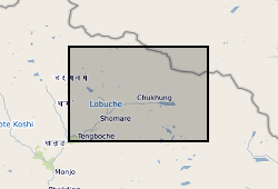
Ground control points for investigating mass loss processes on Khumbu Glacier, Nepal (NERC grant NE/L002574/1)
These data consist of a spreadsheet containing 557 ground control points (GCPs) collected in the Everest region of Nepal between October 2015 and October 2016. GCPs were collected using a Leica GS10 differential Global Positioning System (dGPS), post-processed against base station data at Syangboche. These final data have sub-centimetre accuracy (in x, y and z) in all cases. Point positions are heavily concentrated around meltwater ponds on the glacier surface, and prominent features around the glacier margin. These data will be used by PhD students and staff in the School of Geography, University of Leeds, to provide ground control for fine-resolution satellite imagery and Structure-from-Motion surveys to assess mass loss processes on Khumbu Glacier.
INSPIRE
Identification
- File identifier
- 4e0de6db-4b5b-108d-e054-002128a47908 XML
- Resource type
- dataset
Online resource
Resource identifier
- Metadata Language
- English (en)
Encoding
Projection
Classification of data and services
- Topic category
-
- Geoscientific information
Classification of data and services
Coupled resource
Coupled resource
Classification of data and services
Coupled resource
Coupled resource
Keywords
- GEMET - INSPIRE themes, version 1.0
- BGS Thesaurus of Geosciences
-
-
Glaciers
-
Glacial geology
-
Ground control
-
NGDC Deposited Data
-
Geographic coverage
))
Temporal reference
Temporal extent
Temporal extent
- Dataset Reference Date ()
- 2016-10
Quality and validity
- Lineage
-
557 ground control points (GCPs) collected around Khumbu and Ama Dablam Glaciers during field campaigns in October/November 2015, May/June 2016, and October 2016. GCPs were collected using Leica GS10s in rapid-static mode. GCPs were surveyed in a non-uniform pattern along the margins of respective glaciers or on the surface. GCPs on the margin of glaciers were collected on large boulders or path junctions. Those collected on the glacier were marked using temporary markers for inclusion into a SfM workflow. Base station data were post-processed against the Syangboche permanent station (UTM 45N 471683 m E, 3076653 m N) located ~ 20 km from our field site using Global Positioning System (GPS) and GLObal NAvigation Satellite System (GLONASS) satellites. Our field GCPs were then adjusted with reference to the field base station data following a relative carrier phase positioning strategy. Elevations are to Earth Gravitational Model 2008 (EGM2008).
Conformity
Conformity
Conformity
Conformity
Conformity
Conformity
- Explanation
-
See the referenced specification
Restrictions on access and use
- Access constraints
- no limitations
- Access constraints
- The dataset is made freely available for access, e.g. via the Internet. Either no third party data / information is contained in the dataset or BGS has secured written permission from the owner(s) of any third party data / information contained in the dataset to make the dataset freely accessible.
- Access constraints
-
The copyright of materials derived from the British Geological Survey's work is vested in the Natural Environment Research Council [NERC]. No part of this work may be reproduced or transmitted in any form or by any means, or stored in a retrieval system of any nature, without the prior permission of the copyright holder, via the BGS Intellectual Property Rights Manager. Use by customers of information provided by the BGS, is at the customer's own risk. In view of the disparate sources of information at BGS's disposal, including such material donated to BGS, that BGS accepts in good faith as being accurate, the Natural Environment Research Council (NERC) gives no warranty, expressed or implied, as to the quality or accuracy of the information supplied, or to the information's suitability for any use. NERC/BGS accepts no liability whatever in respect of loss, damage, injury or other occurence however caused.
- Access constraints
-
The dataset is made available to external clients under BGS Digital Data Licence terms and conditions. Revert to the IPR Section (iprdigital@bgs.ac.uk) if further advice is required with regard to permitted usage. iprdigital@bgs.ac The dataset is made available to external clients under BGS Digital Data Licence terms and conditions. Revert to the IPR Section (iprdigital@bgs.ac.uk) if further advice is required with regard to permitted usage.
Responsible organization (s)
Contact for the resource
- Organisation name
-
University of Leeds
-
not available
- Organisation name
-
University of Leeds
-
not available
- Organisation name
-
University of Leeds
-
not available
Responsible organization (s)
Contact for the resource
- Organisation name
-
University of Leeds
-
not available
- Organisation name
-
University of Leeds
-
not available
- Organisation name
-
University of Leeds
-
not available
Metadata information
Contact for the metadata
- Organisation name
-
British Geological Survey
-
enquiries@bgs.ac enquiries@bgs.ac.uk
- Metadata Date
- 2024-04-18
- Metadata Language
- English (en)