BGS Data Catalogue
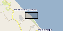
Lincolnshire coast beach-dune surveys December 2013-April 2015 (NERC grant NE/M000052/1)
The dataset contains on-average monthly terrestrial LiDAR surveys conducted on the Lincolnshire coastline following the 2013 storm surge, collected between December 2013 and April 2015. The approximate coordinate locations of the surveys are given as follows: -EmbryoDunes (ED) 53°22'03"N 0°14'54"E -MablethorpeNorthEnd (MNE) 53°21'43"N 0°15'03"E The data were collected to record the rate and nature of recovery of the geomorphology of the back-beach and foredune zones following a storm surge in December 2013. Users interested in nearshore coastal geomorphology dynamics will find the data useful.
INSPIRE
Identification
- File identifier
- 487b5a64-09bb-12f7-e054-002128a47908 XML
- Resource type
- dataset
Online resource
Resource identifier
- Metadata Language
- English (en)
Encoding
Projection
Classification of data and services
- Topic category
-
- Geoscientific information
Classification of data and services
Coupled resource
Coupled resource
Classification of data and services
Coupled resource
Coupled resource
Keywords
- GEMET - INSPIRE themes, version 1.0
- BGS Thesaurus of Geosciences
-
-
NGDC Deposited Data
-
Beaches
-
Dunes
-
Foredunes
-
Coastal features
-
Geomorphology
-
Geographic coverage
))
Temporal reference
Temporal extent
Temporal extent
- Dataset Reference Date ()
- 2015-04
Quality and validity
- Lineage
-
The dataset contains on-average monthly terrestrial LiDAR surveys collected as part of NERC grant NE/M000052/1 'Sensitivity of post-storm surge dune recovery to pre-storm geomorphological variability'. The datasets have been registered to a local OS Grid coordinate system to reduce errors during georeferencing. The files are supplied in comma delimited .csv format with individual points given in Eastings, Northings, Elevation (relative to mean sea level, ODN). The nomenclature given to the files (comma delimited .csv format) is as follows: Date*_Digital Elevation Model**.csv *given in YYMMDD format **as digital surface and terrain models (DSMs and DTMs respectively) The point-cloud data has been filtered using a local block window filter to differentiate between the ground surface (DTM) and supersurficial material (DSM). The window sizes for the ED and MNE sites are 50 and 5cm respectively. The optimal size of window was deduced from a dGPS ground control point comparison. Filtered data has subsequently been clipped to remove areas of low point density (obscuration from scanner). The dimensions of this clip are 65 x 130m (8100m^2) and 40 x 50m (2000m^2) for the respective ED and MNE sites.
Conformity
Conformity
Conformity
Conformity
Conformity
Conformity
- Explanation
-
See the referenced specification
Restrictions on access and use
- Access constraints
- no limitations
- Access constraints
- The dataset is made freely available for access, e.g. via the Internet. Either no third party data / information is contained in the dataset or BGS has secured written permission from the owner(s) of any third party data / information contained in the dataset to make the dataset freely accessible.
- Access constraints
-
The copyright of materials derived from the British Geological Survey's work is vested in the Natural Environment Research Council [NERC]. No part of this work may be reproduced or transmitted in any form or by any means, or stored in a retrieval system of any nature, without the prior permission of the copyright holder, via the BGS Intellectual Property Rights Manager. Use by customers of information provided by the BGS, is at the customer's own risk. In view of the disparate sources of information at BGS's disposal, including such material donated to BGS, that BGS accepts in good faith as being accurate, the Natural Environment Research Council (NERC) gives no warranty, expressed or implied, as to the quality or accuracy of the information supplied, or to the information's suitability for any use. NERC/BGS accepts no liability whatever in respect of loss, damage, injury or other occurence however caused.
- Access constraints
-
Available under the Open Government Licence subject to the following acknowledgement accompanying the reproduced NERC materials "Contains NERC materials ©NERC [year]"
Responsible organization (s)
Contact for the resource
- Organisation name
-
University of Loughborough
-
not available
Responsible organization (s)
Contact for the resource
- Organisation name
-
University of Loughborough
-
not available
Metadata information
Contact for the metadata
- Organisation name
-
British Geological Survey
-
enquiries@bgs.ac enquiries@bgs.ac.uk
- Metadata Date
- 2024-04-17
- Metadata Language
- English (en)