 BGS Metadata Catalogue
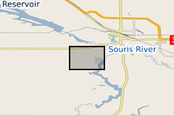
UKCCSRC Call 1 Project: Microseismic and structural geological data collected at Aquistore (Canada)
This data set includes microseismic and structural geological data collected at Aquistore (Canada). They cover a period from 26th April - 21st June 2015, during which CO2 was being injected in the Aquistore injection well at 3.5 km depth. The data were collected in the framework of a research project funded by UKCCSRC (EPSRC) and based at Aquistore in order to identify whether any microseismic events, that could be related to the CO2 injection, took place during this period and use of these events to image potential flowpathways at depth. The data were collected at a sampling rate of 1000Hz using a short-period microseismic array with a 25m aperture, consisting of one three-component and three one-component sensors (Lennartz, MKIII and MKII lite). The array was placed at 50cm depth, approximately 150m away from the injection well. Acquisition was continuous during the above period. The microseismic data are available in PASCAL or ASCII format. Full details on equipment used in data collection and data formats are available in the README file. Due to commercial constraints this dataset is currently under embargo until the end of 2017. Due to the large size of the dataset additional information and access requirements can be requested via the contact email supplied.
Simple
- Date (Publication)
- 2016-09-09
- Citation identifier
- http://data.bgs.ac.uk/id/dataHolding/13607019
- Point of contact
-
Organisation name Individual name Electronic mail address Role University of Strathclyde
Stella Pytharouli
not available
Point of contact
- Maintenance and update frequency
- notApplicable
-
GEMET - INSPIRE themes, version 1.0
- dataCentre
- Keywords
-
-
NERC_DDC
-
- Access constraints
- Other restrictions
- Other constraints
- licenceOGL
- Use constraints
- Other restrictions
- Other constraints
-
The copyright of materials derived from the British Geological Survey's work is vested in the Natural Environment Research Council [NERC]. No part of this work may be reproduced or transmitted in any form or by any means, or stored in a retrieval system of any nature, without the prior permission of the copyright holder, via the BGS Intellectual Property Rights Manager. Use by customers of information provided by the BGS, is at the customer's own risk. In view of the disparate sources of information at BGS's disposal, including such material donated to BGS, that BGS accepts in good faith as being accurate, the Natural Environment Research Council (NERC) gives no warranty, expressed or implied, as to the quality or accuracy of the information supplied, or to the information's suitability for any use. NERC/BGS accepts no liability whatever in respect of loss, damage, injury or other occurence however caused.
- Other constraints
-
Available under the Open Government Licence subject to the following acknowledgement accompanying the reproduced NERC materials "Contains NERC materials ©NERC [year]"
- Language
- English
- Topic category
-
- Geoscientific information
- Geographic identifier
-
SASKATCHEWAN [id=744700]
British Geological Survey Gazetteer: Geographical hierarchy from Geosaurus 1979 creation
))
- Begin date
- 2015-04-26
- End date
- 2015-06-21
Reference System Information
- Distribution format
-
Name Version
- OnLine resource
-
Protocol Linkage Name WWW:LINK-1.0-http--link
https://ptrc.ca/aquistore Aquistore
- OnLine resource
-
Protocol Linkage Name WWW:LINK-1.0-http--link
https://pure.strath.ac.uk/portal/en/datasets/microseismic-data-from-aquistore-canada(0536c9fa-38bd-4d8e-bfdd-637d9ee753e7).html
- OnLine resource
-
Protocol Linkage Name WWW:DOWNLOAD-1.0-http--download
https://ukccs-research.org/accessions/index.html#item70994
- Hierarchy level
- Dataset
- Other
-
dataset
Conformance result
- Title
-
INSPIRE Implementing rules laying down technical arrangements for the interoperability and harmonisation of Geology
- Date (Publication)
- 2011
- Explanation
-
See the referenced specification
- Pass
- No
Conformance result
- Title
-
Commission Regulation (EU) No 1089/2010 of 23 November 2010 implementing Directive 2007/2/EC of the European Parliament and of the Council as regards interoperability of spatial data sets and services
- Date (Publication)
- 2010-12-08
- Explanation
-
See http://eur-lex.europa.eu/LexUriServ/LexUriServ.do?uri=OJ:L:2010:323:0011:0102:EN:PDF
- Pass
- No
- Statement
-
The data were collected at a sampling rate of 1000Hz using a short-period microseismic array with a 25m aperture, consisting of one three-component and three one-component sensors (Lennartz, MKIII and MKII lite). The array was placed at 50cm depth, approximately 150m away from the injection well. Acquisition was continuous during the above period.
Metadata
- File identifier
- 3f2036d6-f332-504d-e054-002128a47908 XML
- Metadata language
- English
- Hierarchy level
- Dataset
- Date stamp
- 2026-06-26
- Metadata standard name
- UK GEMINI
- Metadata standard version
-
2.3
- Metadata author
-
Organisation name Individual name Electronic mail address Role British Geological Survey
Point of contact
- Dataset URI
)))
